Michigan Technological University’s Michigan Tech Transportation Institute (MTTI) and Michigan Tech Research Institute (MTRI), in cooperation with the Center for Automotive Research and the Michigan Department of Transportation, undertook a project for the USDOT Research and Innovative Technology Administration (RITA) that explores the use of remote sensing technologies to assess and monitor the condition of bridge infrastructure and improve the efficiency of inspection, repair, and rehabilitation efforts. The investigation built on existing work that places sensors directly on the bridge structure to assess deterioration and damage.
Remote sensing technologies were correlated with in-place sensors to obtain bridge condition assessment data without the need to place heavy instrumentation on the structure. This information was analyzed by a computer decision support system to develop unique signatures of bridge condition. Monitoring how these signatures change over time provides state and local engineers with additional information used to prioritize critical maintenance and repair of our nation’s bridges. The ability to acquire this information remotely from many bridges without the expense of a dense sensor network provides more accurate and near real-time assessments of bridge condition. Improved assessments allow for limited resources to be better allocated in repair and maintenance efforts, thereby extending the service life and safety of bridge assets, and minimizing costs of service-life extension.
About the Project
Executive Summary
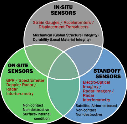
Michigan Tech developed remotely sensed bridge condition signatures that can be used to enhance the effectiveness of bridge inspection teams and improve asset management programs for transportation agencies. Because no single type of sensor can provide all the information needed to assess the condition of a bridge accurately, our approach integrates in-situ field sensors, “local” remote sensing data (such as infrared thermography), and stand-off remote sensing data (such as satellite imagery) to create a unique bridge signature that provides an overall assessment of bridge structural health. These data are integrated within a decision support system (DSS) that applies information from multiple sources, including sensor data; previous inspection results; existing bridge management systems; laboratory-validated models; and meteorological inputs. The "signature" starts with a baseline index that can be used to track changes in bridge condition over time.
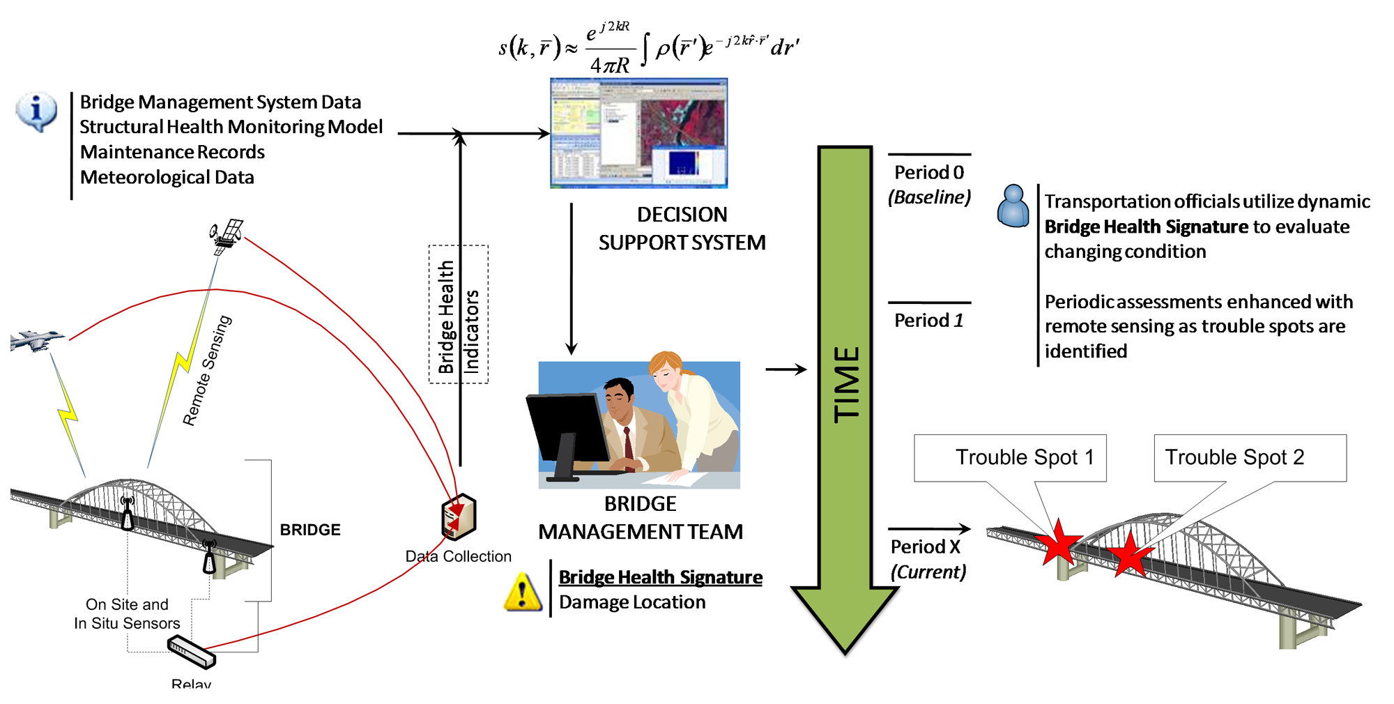
The system adds value by providing bridge asset managers with a tool for obtaining an assessment of bridge condition without having to instrument the bridge. And by providing inspection teams with relevant preliminary condition assessment data, bridge inspection teams can focus their efforts on trouble spots identified by the sensors as evaluated through the DSS. These indicators, combined with models and algorithms validated in the laboratory and historical bridge inspection records, provide the inputs to the DSS. The DSS allows managers and decision makers to prioritize maintenance and rehabilitation efforts based on objective data with analysis capabilities to help monitor condition, changes in condition, and plan for more cost-effective efforts.
Project Goals
The project had three primary goals:
- Establish remotely sensed bridge health indicators
- Develop a baseline bridge performance metric, the bridge condition signature, for benchmarking overall bridge condition
- Provide a system that enhances the ability of state and local bridge engineers to prioritize critical repair and maintenance needs for the nation’s bridges
Background
The condition of the nation’s infrastructure has gained increased attention, primarily as a result of catastrophic events such as the I-35W collapse in Minneapolis in 2007. Deteriorating transportation infrastructure has burdened transportation agencies for many years. Bridges continue to age, and funds for the repair and replacement of this infrastructure are insufficient at current funding levels. The US is home to 600,000 highway bridges. Structural deficiency, which describes the condition of significant load-carrying elements and adequacy of waterway openings, typically relates directly to the age of a bridge (AASHTO 2008). Three percent of bridges between 15 and 19 years old, and 53 percent of those 95 to 100 years old, are structurally deficient (Memmott 2007).
In recent years, structural health monitoring (SHM) for bridges has adopted the “Level IV” approach with a primary focus of accurately monitoring in-situ behavior to assess in-service performance, detect damage, and determine condition of a structure (ISIS 2001). Most research efforts have focused on the subsystems of a structural health monitoring system including static and dynamic field testing, and both periodic monitoring and continuous monitoring, but a complete SHM system also requires routine inspection, data management, data interpretation, and decision support. Recent advances in SHM have included novel sensing technologies and assessment methods such as wireless sensors, strain sensing films and local damage identification, but a complete solution to the challenges described above has yet to be realized. SHM is further complicated by the wide degree of variability in bridge types, materials, operating environments, and structural configurations.
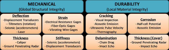
No single SHM method exists that is capable of completely determining the condition of a bridge. Current assessment methods provide critical information about the condition of a bridge, but the data obtained must be interpreted by a skilled professional and are typically limited to local metrics, such as stress, strain, temperature, deflection, moisture, cracking, and delamination.
Remote sensing technologies offer the ability to combine several methods to obtain a more complete assessment. These methods exhibit a divide between metrics for structural response at the global level and material distress at the local level. The combination of these metrics will provide a better picture of overall bridge condition.
Technical Approach
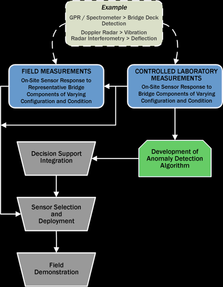
The Michigan Tech team investigated the extent to which remote sensing data, particularly from sources such as aerial and satellite imagery, can be used effectively to monitor components of bridge health, such as the condition of the bridge deck or other structural elements. Stand-off remotely sensed data sources have the potential for effectively monitoring condition and quality of the road and bridge surface, if the imagery data can reliably capture indicators of current and changing condition. Because changes over a two-year period can be minimal, we used the commercial satellite archive available from vendors to determine potential changes over time, while relating condition signatures in imagery to a sample of current different high, low, and moderate quality conditions on bridges. With these methods, we were able to report on what the remotely sensed data are capable of telling transportation agency bridge assessment teams in a cost-effective and timely manner. The program achieved this assessment through a combination of controlled laboratory experiments, field demonstrations, and data analysis.
On-Site Sensor Applications
On-site sensors make non-contact measurements in close proximity to bridge structures to nondestructively sense the surface and/or interior conditions. The specific aims of the on-site sensor assessment were:
- To determine, through controlled measurements, that on-site sensors can make quantitative measurements of bridge component structural health
- To provide data to develop and demonstrate automated data processing algorithms to facilitate the cost effective use of on-site sensors by bridge inspectors and to provide quantitative structural health data to the DSS
- To provide data to determine if comparable remote sensors can make similar quantitative measurements at longer distances
Remote Sensing Applications
Satellite and airborne-based remote sensing shows increasing promise for monitoring the condition of road surface infrastructure. This project validated and applied this capability to assess and monitor the condition of the bridge elements that are critical to bridge operation.
Three commercial Synthetic Aperture Radar systems (PALSAR, RADARSAT-II, and ENVISAT) can potentially measure both bridge vibration and deflection. We determined the sensitivity requirements to make these measurements using stand-off remote sensors, and then evaluated both theoretically and experimentally, whether these existing commercial sensors can provide the required information. These SAR systems provide the required temporal synoptic coverage at affordable cost to perform a wide area bridge assessment.
Sensor Validation and Field Studies
Representative bridge component structures, such as concrete bridge decks and supports, with varying levels of damage and material contamination are used to obtain sensor data.
The sensor data is compared with the sample ground truth data to define the quantitative relationship between sensor data and various levels of bridge component damage or contamination. The data collected was also used to develop and validate data processing algorithms for the DSS.
Once the relationships between sensor signatures and structural damage were defined and the automated data processing algorithms were developed, the combined measurement/data processing system was tested at field sites identified in conjunction with MDOT that are representative of typical operational bridge inspection situations. A series of field tests were conducted to determine an initial bridge signature based on verified technologies.
Decision Support System
The Bridge Condition Decision Support System will include the ability to apply algorithms used to extract and combine relevant condition information from sensor data, compare current sensor data to historical data to establish trends, and make recommendations to ensure optimal bridge health using cost-effective maintenance and repair protocols. As part of an integrated bridge assessment, the DSS was able to take advantage of historical data from existing systems. For our study area these were the Michigan Bridge Inspection System (MBIS) and Michigan Bridge Reporting System (MBRS).
Combining data from on-site sensors, in-situ sensors, and stand-off remote sensing using appropriate statistical algorithms, the DSS integrated data to support and expand current bridge monitoring practices. The figure shows how sensors fed into the DSS.
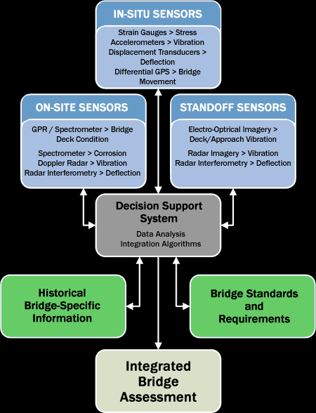
We plan for users to be able to select particular bridges through a mapping interface, and then be able to query historical and newly sensed data, along with algorithm-based analysis results that support cost-effective bridge monitoring and maintenance. Understanding and reporting on the extent to which the DSS is producing useful and consistent measures that are timely and cost-effective for bridge assessment teams was addressed by working closely with the input of our technical advisory committee.
Technical and Economic Assessment
A technical assessment and economic evaluation was conducted as part of the project. The technical assessment evaluated the DSS tool, its technical components (such as models and algorithms), and the sensor inputs to determine how well they perform in demonstrating integrated bridge assessments that are useful for the transportation agency end-user. This included assessing the accuracy and reliability of bridge inspection measurements made by tested sensors and comparing these measures to standard measures used by bridge.
The economic evaluation examined the costs of the developed sensing techniques and evaluate these costs in relationship to the added value that the techniques supply in terms of improved bridge health monitoring. Ultimately, this task answers the question of whether the developed techniques are cost effective or not as demonstrated, with an analysis of likely future costs for full implementation.
Tasks and Deliverables
Task 1 Project Administration
January 2010–January 2012
- Deliverable 1-A: Quarterly Reports
- Deliverable 1-B: Final Report Main Body and Appendices
Task 2 Bridge Condition Characterization
February 2010–October 2011
- Deliverable 2-A: State of the Practice Synthesis Report
- Deliverable 2-B: Laboratory Testing and Simulations Findings Report
- Deliverable 2-C: Models, simulations, and data on remote sensing response to bridge characteristics
Task 3 Commercial Sensor Evaluation
April–August 2010
- Deliverable 3-A: Report detailing results of commercial sensor evaluation including describing which sensors can perform most efficiently on measuring high-priority bridge condition characteristics
Task 4 Decision Support System
July 2010–March 2011
- Deliverable 4-A: Demonstration Decision Support System (DSS) available to project stakeholders through a secure web portal
- Deliverable 4-B: Report summarizing the DSS including descriptions of its components, how it integrates sensed and historical data to support bridge assessment, the algorithms and models it applies, how they were developed, and how the DSS could be moved towards operational status
Task 5 Field Demonstration
January–October 2011
- Deliverable 5-A: Report summarizing the field demonstration results of remote sensing applications for bridge condition assessment on two selected bridges
- Factsheet on the 3D Optical Bridge-evaluation System (3DOBS)
Task 6: Assessment
October 2011–January 2012
- Deliverable 6-A: Report summarizing the results of the technical assessment and evaluation
- Deliverable 6-B: Report detailing the results of the economic evaluation
Project Team and Partners
![]()
Richard Wallace
Richard Wallace, M.S., is a Senior Project Manager with CAR. He serves as the project manager for CAR’s vehicle-infrastructure integration efforts with the Michigan Department of Transportation and plays a leading role in CAR’s work on current projects involving technology for transportation infrastructure monitoring. He will take a lead role in the technical evaluation and economic assessment tasks, as well as liaison with MDOT. Prior to rejoining CAR in April 2007, Mr. Wallace held the position of Research Scientist with the Michigan Tech Research Institute (MTRI). At MTRI, Mr. Wallace served as one of the lead scientists for MTRI’s “Transportation Applications of Restricted Use Technology Study” and led two of the four pilot studies that MTRI implemented in cooperation with the Michigan Department of Transportation, including those associated with traffic queues and delay and estimation of AADT with remote sensing.
Email: rwallace@cargroup.org
![]()
Project Partner
Technical Advisory Committee
Documents
Deliverable 1-A: Quarterly Reports
- Quarter 1
- Quarter 2
- Quarter 3
- Quarter 4
- Quarter 5
- Quarter 6
- Quarter 7
- Quarter 8
- Quarter 9
- Quarter 10
Members and Affiliations
- Steve Cook, Michigan Department of Transportation (MDOT)
- Douglas Couto, Transportation Research Board (TRB)
- Michael Johnson, CALTrans
- Dan Johnston, Independent Materials Consultant
- Dennis Kolar, The Road Commission for Oakland County
- Duane Otter, Transportation Technology Center, Inc.
- Keith Ramsey, Texas Department of Transportation
- Carin Roberts-Wollmann, Virginia Tech
- Roger Surdahl, Federal Highways Administration (FHWA)
- Peter Sweatman, University of Michigan Transportation Research Institute (UMTRI)
- Amy Trahey, Great Lakes Engineering Group
Related Resources
- National Consortia on Remote Sensing in Transportation (NCRST)
- TRB Subcommittee on Sensing Technologies for Transportation Applications
Other NCRST Programs
- Environment and Planning—Mississippi State University
- Freight: Border Crossings—Ohio State University
- Freight: Congestion Pricing—Rensselaer Polytechnic Institute
- Freight: Metropolitan Ports—University of California at Santa Barbara
- Infrastructure: Bridges—University of North Carolina at Charlotte
- Infrastructure: Pavement—Western Research Institute
- Infrastructure: Rural Roads—South Dakota State University