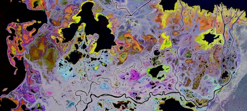
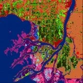
New approaches have been developed for mapping and monitoring land cover/land use at moderate resolution (30 m) with a focus on wetlands using a fusion of multi-sensor, multi-temporal satellite radar imagery (e.g. PALSAR-2 and Radarsat-2) and traditional multi-spectral data (Landsat, Sentinel-2). Wetlands have historically been one of the most difficult ecosystems to classify using remotely sensed data. This difficulty is partially due to the high variability in wetland morphology. Our results show how SAR and multi-spectral sensors complement each other in the classification of wetland ecosystems, allowing greater mapping accuracy for both wetland and non-wetland categories. These sensors allow for identification of specific wetland species of interest, including the invasive species, Phragmites, as well as the ability to distinguish ecotypes, such as differentiating bogs from fens. While multi-spectral data measure spectral reflectance and emittance characteristics of various cover types and wetness in open canopied ecosystems, SAR is sensitive to variations in biomass, structure, dielectric properties and flood condition of landscapes including forests and other closed canopy ecosystems. Our mapping approach integrates field data collected from plot sizes that are commensurate with the resolution of the imagery and interpretation of high resolution aerial or satellite imagery to create suitable training and testing data. These training data are used as input to a machine learning algorithm with multiple dates of L- and/or C-band satellite SAR data combined with multi-spectral imagery and DEM derivatives. The multi-date SAR data allows for inclusion of hydrological conditions (wet soil, low to high inundation) from different seasons while the multi-date optical imagery captures the vegetation phenology. While the methods were developed for land cover and land use classification across the Great Lakes, the multi-sensor, multi-temporal techniques have been demonstrated in boreal Alberta and Northwest Territories, Canada, in the tropical alpine regions of Peru, Ecuador and Colombia, in tropical lowland systems of the Amazon Basin, and most recently in grasslands of Kenya. Overall accuracies have been greater than 93% using independent validation data for most regions.
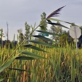
Additional efforts have been made to monitor changes in Phragmites cover using high resolution imagery collected with commercial and UAV platforms. High resolution imagery provides detailed spectral information that is used to observe individual Phragmites stands and how they change with time. These high resolution data can be useful in evaluating treatment efforts being conducted to remove Phragmites and monitor how wetlands are changing in relation to changing water levels in the Great Lakes.
Citations
Projects

Vernal Pools
In this collaborative effort, MTRI has developed remote sensing toolchains to support a NASA program to identify vernal pools around the great lakes region
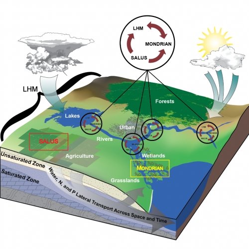
Quantifying how Global Change and Land use Legacies Affect Ecosystem Processes at the Land Water Interface across the Great Lakes Basin
Historic changes in land use and cover along the coasts of the Great Lakes have influenced the spread of invasive species into wetland ecosystems. The goal of this project is to utilize past efforts at quantifying these influences and extend the results both spatially and temporally across the Great Lakes Basin. We will couple agricultural, ecological, hydrological processed-based models in conjunction with remotely sensed data to observe how changes in land use have affected the spread of invasive species and make estimates of future changes.
Linking Science with Wetland Management of Invasive Phragmites
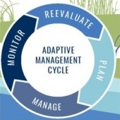
A team of remote sensing experts, ecosystem modelers, wetland managers, and ecologists worked together to develop a strategic plan for control of the invasive plant Phragmites australis in the Saginaw Bay that would take into account nutrient loading, landscape position, pre- and post-treatment monitoring and site specific conditions for an adaptive management approach. Two grants provided various aspects of the project outputs.
Arresting the Spread of Eurasian Watermilfoil (Myriophyllum spicatum) in the Great Lakes
In this collaborative Great Lakes Restoration Initiative project, we tool a multi-faceted analysis and extension approach aimed at arresting Eurasian Watermilfoil in its early stages in the Upper Great Lakes so similar invasions do not become the norm.
Midwest Wetlands Assessment and Advanced Wetlands Mapping Support for USFWS Region 3 Ecological Services
MTRI performed an accuracy and agreement assessment of St. Mary’s University’s analysis of an updated National Wetlands Inventory. MTRI also reported on improved wetlands mapping methods.
Radar Detection and Monitoring of Invasive Phragmites in the Coastal Great Lakes
This project, developed and initially funded by the USGS Great Lakes Science Center, is focused on looking at Phragmites distribution and expansion throughout the Great Lakes basin. Recognizing MTRI’s expertise in satellite data analysis, and more specifically imaging radar analysis, USGS employed MTRI to cooperatively work on the mapping component of this project.
A Baseline and Standardized Method for Monitoring the Treatment of Invasive Phragmites
The purpose of the study was to develop scientific methods for monitoring the effectiveness of herbicide spraying as a management technique for controlling the invasive species, Phragmites australis. Focus was on the evaluation of effectiveness of past herbicide treatments on Phragmites, and post-treatment restoration response of vegetation and faunal biodiversity.
![]()
Monitoring Forest Soil Moisture for a Changing World
MTRI and the USDA Forest Service hosted a facilitated workshop on Monitoring Forest Soil Moisture for a Changing World in Ann Arbor, Michigan on May 15-17, 2018. The overarching goal was to develop a new strategic approach of research and monitoring on soil moisture issues for forest areas of the United States.
Linking Remote Sensing and Process-Based Models to Assess Land Use and Climate Change Impacts on Plant Invasion in Great Lakes Coastal Wetlands
Our objective is to refine and integrate process-based hydrological and ecological models with remote sensing products to investigate how changes in upland land use and climate alter risk of plant invasions and ecosystem services in coastal wetlands.
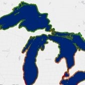
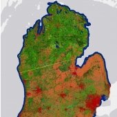
Great Lakes Coastal Wetland Mapping
Long-term monitoring of Great Lakes coastal wetlands is accomplished using SOLEC (State of the Lakes Ecosystem Conference) or GLEI (Great Lakes Environmental Indicators) indicators. Our map is the first comprehensive wetland delineation of the bi-national coastal Great Lakes, and includes adjacent land use and at least two invasive plant species: Typha spp. and Phragmites australis.
Learn how invasive species impact the economy.
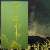
Les Cheneaux Islands Eurasian Watermilfoil Control
This project implemented a medium-scale (up to 10 acres/year) biopesticide treatment using the indigenous fungus Mt and other techniques for control of invasive Eurasian watermilfoil in the Les Cheneaux Islands of Lake Huron. Treatment outcomes as well as longer-term effects of previous releases of the fungus and a milfoil weevil were evaluated.
Learn outcomes of the treatment plan.