Overview
The purpose of the study was to develop scientific methods for monitoring the effectiveness of herbicide spraying as a management technique for controlling the invasive species Phragmites australis. Focus was on the evaluation of effectiveness of past herbicide treatments on Phragmites, and post-treatment restoration response of vegetation and faunal biodiversity. Treatment effectiveness was assessed in a nested scaling design, from field surveys to high-resolution aerial imagery to moderate resolution satellite imagery.
New aerial imagery was collected, interpreted, and classified for Phragmites identification, effectiveness of herbicide treatment, and wetland restoration. Standardized biodiversity sampling protocols currently used by the Great Lakes Instrumentation Collaboratory (GLIC) were used for continuity. Cost-efficient monitoring methods were developed for satellite-based Landsat 8 and PALSAR-2 imagery, cross-walked with airborne high resolution multispectral imagery; allowing continued monitoring of Phragmites treatment into the future.
This study provides:
- Improved understanding of the field and remote sensing approaches for assessing the effectiveness of herbicide efforts on the management and control of invasive Phragmites and the restoration of coastal wetlands (biodiversity)
- A thorough investigation of the literature and compilation of results for adaptive management recommendations
Two Study Areas
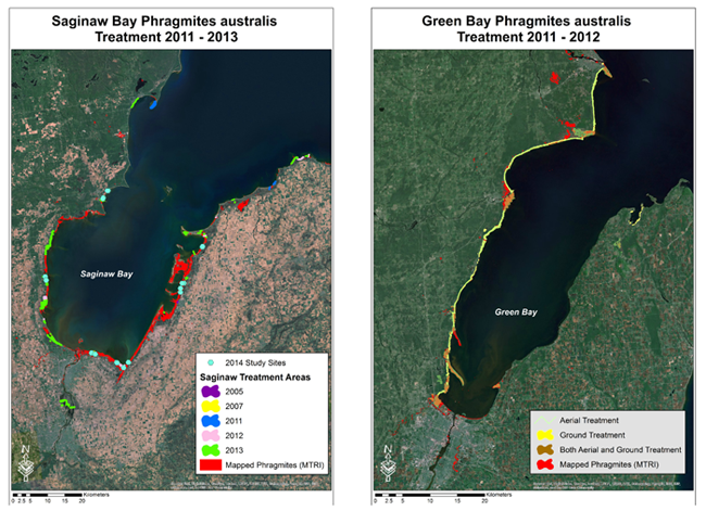
Green Bay, Wisconsin had blanket herbicide treatment in 2011-12 by Wisconsin DNR and Saginaw Bay, Michigan has had limited treatment by individual organizations from 2006 to 2013.
Vegetation Survey Methodology
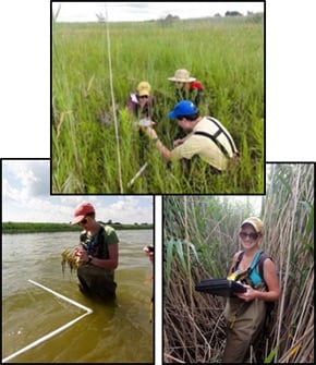
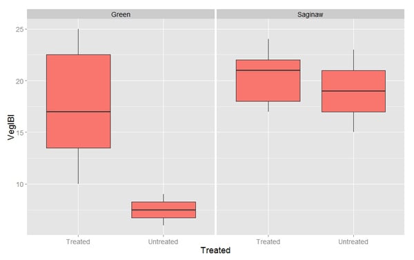
Paired treated and non-treated sites were designed for biodiversity field sampling comparisons. There were 16 paired sites with 40 vegetation transects in Saginaw Bay and 4 paired sites with 24 vegetation transects in Green Bay. The vegetation transects were run from the upland edge through the submergent zone, parallel to the flow of water. Within the 15 1m plots along each transect, all vegetative species were recorded for percent cover. IBI's for the vegetative data were then calculated using invasive cover, invasive frequency, and mean conservatism by vegetative zone.
Field Based Biodiversity Analysis
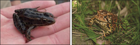
Indicators of Biological Integrity (IBI's) developed by the Great Lakes Coastal Wetlands Consortium are being used to assess biodiversity of Birds, Amphibians, and Vegetation.
Field Survey Results
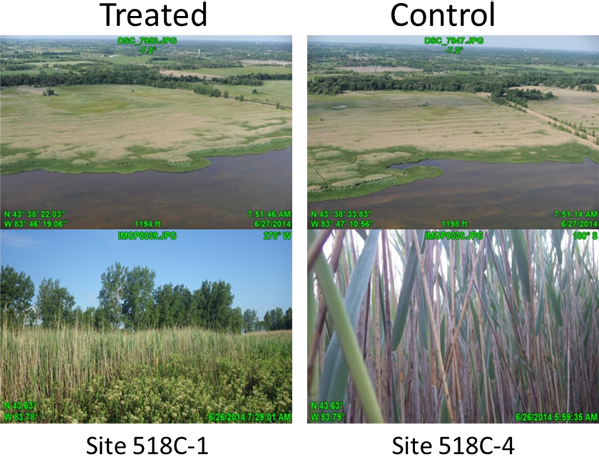
Of the three variables analyzed for this study (vegetation, anurans, birds), the results of the vegetation surveys provided the strongest indication of a positive effect of Phragmites treatment on biodiversity (i.e. the mean species diversity of native plants increased significantly following Phragmites treatment). In comparing post-treatment effects in Green Bay and Saginaw Bay the statistical analysis indicated that live Phragmites cover was reduced significantly by the 2011/2012 treatment activities along western Green Bay whereas, in Saginaw Bay, analyses indicated that the patchwork of treatments applied there during the same period did not have a strong effect on the percent cover of live Phragmites. This suggests that the regional-scale, aerial spraying approach adopted in Green Bay was much more effective at controlling Phragmites than the property-scale management patchwork of actions in Saginaw Bay. By applying a landscape-scale treatment, propagule pressure is also being reduced and this may be a factor in the success. However, timing and application of treatment in Saginaw Bay were variable and most sites lacked follow-up treatment or mowing/burning which are also factors in the success.
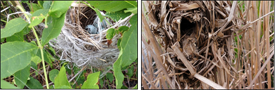
The responses of wildlife species to Phragmites invasion and control are individualistic and complex. For some species, dense Phragmites growth provides no habitat value, but for others, including some declining species, Phragmites serves as a food source, shelter, nest material, and/or buffer vegetation. The anuran and bird data collected in Green Bay and Saginaw Bay between 2011 and 2015 revealed no strong impact of Phragmites invasion on anuran communities. It should be pointed out that overall year-to-year variations in surveys were sometimes large even in the absence of treatment. Multiple recent studies have identified a link between Phragmites cover and the probability of habitat desiccation (Mazerolle et al., 2014; Perez et al., 2013). However, Mazerolle et al. concluded that Phragmites invasion did not appear to be an important driver of population dynamics compared to the influence of the landscape matrix surrounding breeding wetlands.
While point count surveys provide information about the assemblage of wildlife species breeding at a site, they do not characterize breeding success. In addition, dynamics in recruitment from a wider region could mask local effects on breeding success. In this context, point count surveys might best serve as a preliminary monitoring tool to screen for the presence of rare or special-concern species. If found, a protocol that monitors the demographic parameters of those species (i.e., nesting productivity, post-fledging productivity, recruitment, or survivorship) can then be put into place. One important impact that our study did reveal is that marsh nesting obligate species were negatively affected by mowing of Phragmites in the short- to medium-term because they rely on that cover for nesting. Thus, it would be a good management practice to mow in patches over time to reduce the effects on marsh nesting obligates when present.
Mapping
Practitioners often emphasize early detection and treatment of outliers and prioritizing treatment in valued areas using well established techniques. However, they often lack comprehensive distribution maps that clearly show outliers, pathways, and sources at a fine enough scale to be useful.
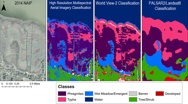
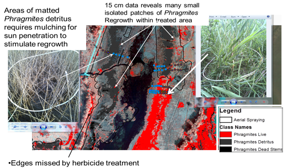
Aerial and satellite imagery were used to map the extent of the Phragmites invasion, including areas of standing dead and fallen stems, as well as the leading edges and other vegetation cover. Three different maps with varying resolutions and data sources were created to help determine and compare the different uses in managing invasive Phragmites. The highest resolution images (15 cm) offer the most detail of Phragmites condition (live, dead standing, fallen detritus) and pick up even the smallest patches, regional mapping for broader scale management may provide sufficient resolution and there is a trade-off between cost and resolution.
Aerial Image Analysis
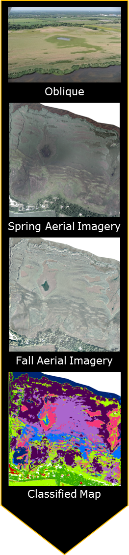
Aerial Imagery Classification
Saginaw Bay
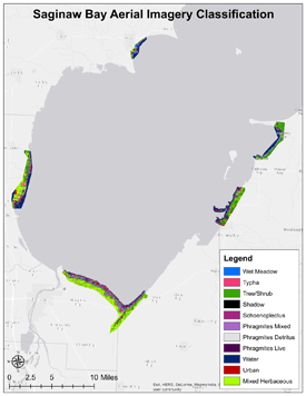
Zip file of Saginaw Bay low and high res images.
Green Bay
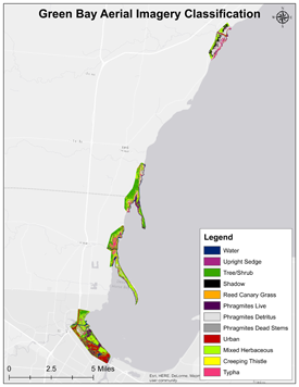
Zip file of Green Bay low and high res images.
PALSAR-2/Landsat 8 Classification
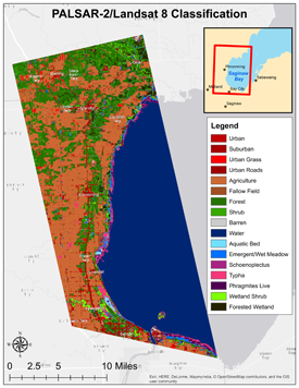
Zip file of PALSAR-2/Landsat 8 low and high res images.
WorldView-2 Classification
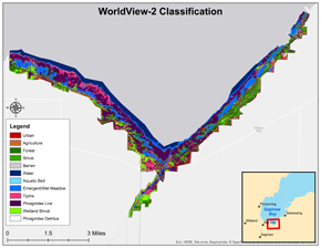
Zip file of WorldView-2 low and high res files.
References
Burton, T. M., Brazner, J. C., Ciborowski, J. J. H., Grabas, G. P., Hummer, J., Schneider, J., & Uzarski, D. G. (2008). Great Lakes coastal wetlands monitoring plan: Great Lakes Commission.
Mazerolle, M. J., Perez, A., & Brisson, J. (2014). Common reed (Phragmites australis) invasion and amphibian distribution in freshwater wetlands. Wetlands Ecology and Management, 22(3), 325-340. Available at: https://phragmites.crad.ulaval.ca/files/phragmites/Mazerolle-et-al.-2014b.pdf
Perez, A., Mazerolle, M. J., & Brisson, J. (2013). Effects of exotic common reed (Phragmites australis) on wood frog (Lithobates sylvaticus) tadpole development and food availability. Journal of Freshwater Ecology, 28(2), 165-177.