Online Education for Working Professionals
Prepare for the mapping use of unmanned aerial systems (UAS).
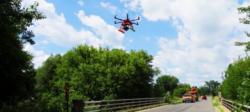
Meet the industry demand for skills in the exploration of geospatial data.
Gain applied geospatial science and technology skills, including sensors and their
calibration methods. Learn digital photogrammetry and photogrammetric computer vision.
Engage in UAS flight planning and Earth Observation Systems (EOS) imagery photogrammetric
processing. Formulate digital representations of 2D products and 3D models. Expand
your career in geospatial engineering and integrated geospatial technology, civil
engineering, forestry, geosciences, computational sciences, and computer engineering.
Be prepared for the professional certifications as ASPRS Mapping Scientists or UAS
Scientists. Photogrammetry jobs pay an average of $86,690 per year (U.S. Bureau of Labor Statistics).
Figures from U.S. Bureau of Labor Statistics (BLS), dated May 2025.
Request Info
How to Apply
3 courses in 3 semesters.
| Length |
3 courses in 2-3 semesters |
| Effort |
3 hours per credit per week |
| Each course |
3 credits |
| Total credits |
9 |
| Course type |
Online or on-campus |
| Modality |
Watch class recordings on demand |
| Cost |
Based on credits and course type |
| Already enrolled? |
Speak with your advisor |
Curriculum
Progress quickly with a compact curriculum. Work with the program advisor to select
courses that fit your interests and pre-requisite skills.
Required Courses
Take 6 credits of required courses.
SU 5140 - Photogrammetry & UAV Mapping
Basic principles of photogrammetry and its role as a technology for spatial data collection. Use of photogrammetry in the fields of surveying, engineering, and geographic information management will be discussed.
- Credits:
4.0
- Lec-Rec-Lab: (0-3-2)
- Semesters Offered:
Fall
- Restrictions:
Must be enrolled in one of the following Level(s): Graduate
SU 5541 - Close-range Photogrammetry
The main topics that will be covered are: math fundamentals; imaging technology; the photogrammetric process; image acquisition planning; interior orientation; bundle block adjustment; 3D plotting; orthoprojection; image-matching techniques; and close range photogrammetry applications.
- Credits:
3.0
- Lec-Rec-Lab: (0-3-0)
- Semesters Offered:
On Demand
- Restrictions:
Must be enrolled in one of the following Level(s): Graduate
- Pre-Requisite(s): SU 4140
Electives
Take a 3-credit elective course.
SU 5010 - Geospatial Concepts, Technologies, and Data
High-level review of geospatial data acquisition systems, sensors and associated processing technologies. Course considers geospatial metadata generation principles, interoperability, and major tools for manipulation with geospatial data. Course may help in transition of non-geospatial majors to geospatial field.
- Credits:
3.0
- Lec-Rec-Lab: (0-3-0)
- Semesters Offered:
Spring
- Restrictions:
Must be enrolled in one of the following Major(s): Integrated Geospatial Tech, Surveying Engineering, Geospatial Engineering
SU 5142 - 3D Surveying and Modeling with Laser Scanner Data
Theory and application of terrestrial LIDAR scanning. Typical application scenarios are also included. Intensive lab component provides hands-on experience in LIDAR point cloud processing and visualization.
- Credits:
3.0
- Lec-Rec-Lab: (0-2-2)
- Semesters Offered:
Fall
- Restrictions:
Must be enrolled in one of the following Level(s): Graduate
SU 5013 - Hydrographic Mapping and Surveying
This course comprises theory and applications of hydrographic mapping technologies. Typical application scenarios are covered. An intensive lab component provides hands-on experience in hydrographic data processing and visualization.
- Credits:
3.0
- Lec-Rec-Lab: (0-2-1)
- Semesters Offered:
Spring
Typical Schedule
The minimum completion time is one semester.
- Fall:
SU 5140
- Spring:
SU 5540
SU 5541
Application Process and Admissions Requirements
Applications are reviewed on an individual basis using a holistic approach. Fill out
our free graduate application online to apply to any of our programs. Official transcripts and scores are not required
for the initial application, although you will need to upload them later.
Graduate School Admissions Process
Applying to the Graduate School is free (no application fees) and fast (no official transcripts, test scores, or letters needed to start). The application
process involves three easy steps.
See Admissions Steps
Graduate School Requirements
To be considered for admission to the Graduate School as a degree- or certificate-seeking student, you need to:
- have a bachelor's degree or its equivalent from an accredited institution, and
- be prepared for advanced study in your chosen field, as demonstrated by your previous
degree and your scholastic record.
See additional application requirements, including required materials:
Program Specific Requirements
Program Specific
- Admitted applicants typically have an undergraduate GPA of 3.0 or better on a 4.0
scale
- GMAT/GRE: Not required
- Preferred major: Civil, environmental or related degree
International Students
- TOEFL scores as of January 21, 2026: Recommended Score of 4.5
- For tests taken before January 21, 2026: Recommended Score of 79 iBT
- IELTS: Recommended Overall Band Score of 6.5
Admissions Decisions
Made on a rolling basis.
Prospective Students
- Prospective students and non-degree seeking students interested in obtaining a graduate
certificate must apply to the certificate program using the online application.
- Accelerated certificate options exist for current Michigan Tech undergraduate students in good standing and have
achieved at least junior-level standing or recent bachelor’s graduates of Michigan
Tech (less than two years).
- The number of credits earned prior to admission that can be counted are restricted.
Current Graduate Students
- Current Michigan Tech graduate students who are in a degree program do not need to formally apply. Current students must still submit the appropriate degree schedule in order to complete the certificate.
International Student Requirements
International Students must apply and be accepted into a degree-granting program in order to earn a graduate certificate. A non-refundable $10 processing fee per application is required.
See International Applicants
Interested in taking a single, online course? Enroll as a non-degree seeking student.
Upon completion of the Certificate the student should be able to:
- Solve photogrammetric engineering problems, and apply their solution to real world
application scenarios.
- Process photogrammetrically UAS and satellite imagery to extract positionally accurate
geospatial information.
Michigan Tech was founded in 1885.
The University is accredited by the Higher Learning Commission and widely respected
by fast-paced industries, including automotive development, infrastructure, manufacturing,
and aerospace. Michigan Tech graduates deliver on rapid innovation and front-line
research, leaning into any challenge with confidence.
The College of Engineering fosters excellence in education and research.
We set out as the Michigan Mining School in 1885 to train mining engineers to better
operate copper mines. Today, more than 60 percent of Michigan Tech students are enrolled
in our 17 undergraduate and 29 graduate engineering programs across nine departments.
Our students and curriculum embrace the spirit of hard work and fortitude our founders
once had. Our online graduate courses are the same, robust classes taken by our doctorate
and masters candidates, taught directly by highly regarded faculty, with outstanding
support from staff. We invite working professionals to join these courses, bring their
own experience and challenges as part of the discussion. Leverage the national reputation
of Michigan Tech to advance your career in tech leadership.