Peatlands cover 3 percent of land and store 30 percent of soil carbon.
Called swamps, bogs, marshes, muskegs, and quagmires, peatlands are much more than wet, low-lying areas. Despite such ignoble nomenclature, the planet needs peatlands.
“All ecosystems store carbon, but wetlands store a lot more than all the rest,” says Rod Chimner, professor in the School of Forest Resources and Environmental Science. Peatlands cover just 3 percent of the Earth’s land, but store approximately 30 percent of the Earth’s soil carbon. When peatlands degrade, the carbon releases into the atmosphere, which contributes to climate change. Following the October 2018 publication of the Intergovernmental Panel on Climate Change’s most recent report, the need for carbon sequestration to fight rising global temperatures is more imperative than ever to prevent catastrophic climatic changes.
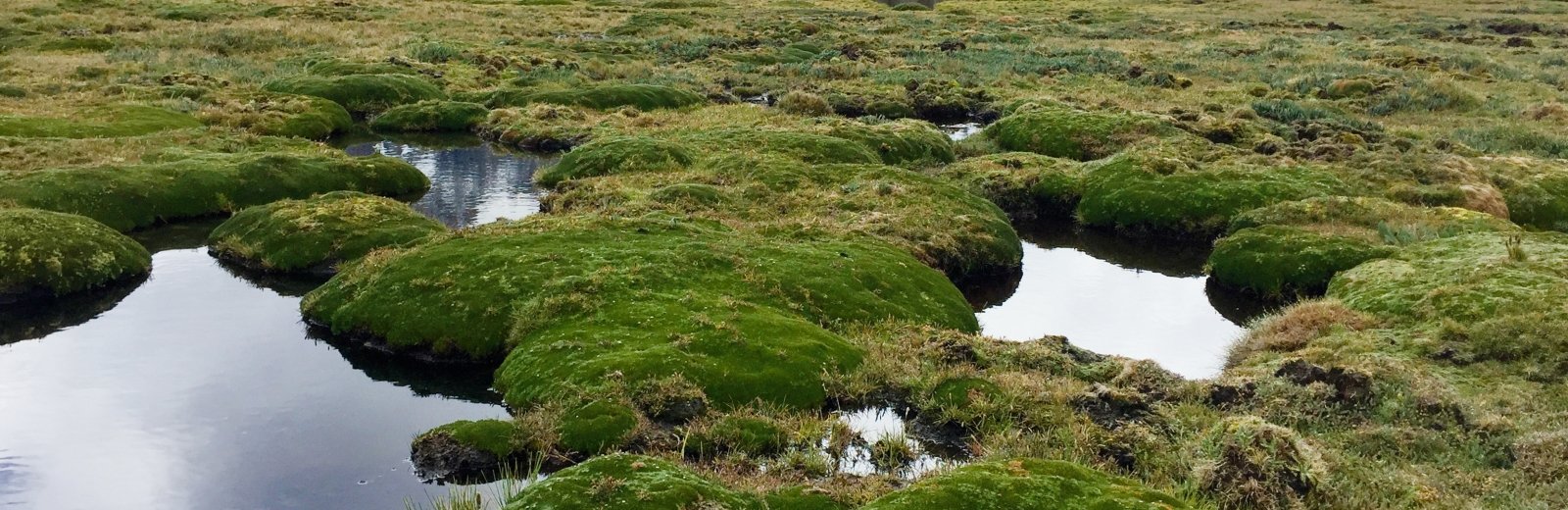
Peatlands occur across the planet in low-lying boreal, temperate, tropical, and even mountainous regions. Mountain peatlands thrive where it’s cool and wet, perfect conditions for slow decomposition of organic material—the process by which peat is created.
Rod Chimner, John Hribljan, and master’s student Ana Maria Planas Clarke coring an 11-meter (36 feet) deep peatland in Los Nevados National Natural Park, Colombia.
Nestled in the high valleys between the 20,000-foot peaks of the Andes, the peatlands of Colombia, Ecuador, Peru, and Bolivia do more than act as carbon sinks. They also purify water as it travels from the mountains to the arid cities along South America’s western coast, cycle nutrients, and provide grazing areas for native camelids like llamas, alpacas, guanaco, and vicuña as well as cattle and horses.
Overgrazing and other human activities lead to peatland degradation around the world. Chimner explains that for global carbon accounting to remain balanced, peatlands need to function as carbon-capture systems, and the nations where peatlands occur need tools to protect them.
Measuring
Chimner’s work in the Andean peatlands is in partnership with the Sustainable Wetlands Adaptation and Mitigation Program (SWAMP), a joint program through the Center for International Forestry Research, the US Forest Service (USFS), Michigan Tech, and Oregon State University with funding support from the US Agency for International Development. Chimner first came into partnership with SWAMP through his past work on Andean peatlands funded by a National Geographic Society Research Exploration grant.
As the effects of climate change increasingly impact people’s daily lives, many nations see value in measuring their carbon stocks—the amount of carbon stored in a given area—and taking steps to ensure the carbon is not released into the atmosphere. One of SWAMP’s primary goals is to help nations quantify their carbon stocks—a process that involves coring peat samples, in situ gas emission analysis, and extensive mapping.
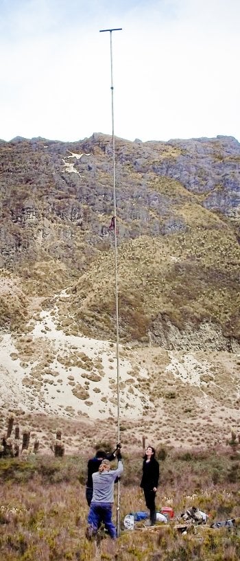
Coring peat is more than a scientific endeavor; it’s also a great workout. Using a Russian peat corer, which is a side-cutting auger made of aluminum, Chimner, a post-doctoral researcher, and graduate students extract peat 50 centimeters (approximately 1.6 feet) at a time, delving as deep as 11 meters (approximately 36 feet).
Twist, twist, twist, side cut, lift the sample out. Add five-foot handle sections to continue going deeper into the peat. Attach a carjack to help pull the increasingly long corer out of the ground. Stop to admire the scenery because it’s breathtaking—and so is the coring effort, which frequently occurs at 14,000 feet in elevation or higher.
The team chunks the 50-centimeter (20 inches) sections into 10-centimeter (4 inches) samples to analyze in the lab for mass, percent carbon, and bulk density to calculate total carbon stocks. The samples are like fine compost, but old roots add structure to the peat so it isn’t crumbly. They use radiocarbon dating to calculate a peatland’s age and how fast it accumulates peat.
For reference, Indonesian peatlands are known as the deepest in the world. They are capable of storing upwards of 3,000 megagrams per hectare of carbon—which is 3 million kilograms (roughly 6.6 million pounds) of carbon in an area one-kilometer square (.38 miles square), or the equivalent of stacking 1,743 sedans in a suburban backyard.
Michigan wetlands store about 1,200 megagrams per hectare of carbon, while peatlands in the Amazon store slightly less than 2,000. Mountain peatlands are capable of storing up to 4,000.
Here and there, too, are gray layers in stark contrast to the darker peat. These ash layers accumulated from volcanic eruptions, which scientists use like mile markers to accurately date the age of the peat. Once, while coring in Colombia, Chimner’s Colombian guide said they were the only people in Los Nevados National Natural Park—because it had been closed due to volcanic activity.
"No one ever thought these mountains would have this much carbon. They have some of the highest storing capabilities in the world."
Moving south through Andean ecosystems, the vegetation changes dramatically from the rainy páramo of Colombia and Ecuador to the drier puna of Peru and Bolivia. Colombia’s and Ecuador’s peatlands are frequently comprised of sedges, grasses, and cushion plants—a misleading name as the green, hump-like mounds are quite hard because they are adapted to high, cold, and windy areas. A human can walk across them, but the hooves of grazing animals can break down the mounds. The páramo’s weather presented a challenge to sampling because the constant rain blurred the landscape, making it difficult to distinguish the peatlands.
In Southern Peru and Bolivia, the arid conditions made it easy to find the wetlands, but the many wet meadows interspersed with the peatlands had similar vegetation, again making distinguishing the two difficult. However, the carbon stocks of wet meadows are much smaller than the peatlands, so classifying them correctly is important to accurately calculate carbon stocks. Confusing matters in the field, wet meadows and peatlands are frequently called by the same name—bofedales—and Chimner says this has befuddled land managers, scientists, and carbon stock accounting in the past. To distinguish wetland types, Chimner and others are combining soil samples with other methods, including ground-penetrating radar and extensive remotely sensed mapping.
In addition to mapping peatlands, three long-term research sites were monitored in Colombia, Ecuador, and Peru to quantify greenhouse gas emissions in areas unaltered by humans or grazing, and those provide a picture of whether a particular peatland is acting as a carbon sink or a carbon source. Chimner and colleagues conduct greenhouse gas flux measurements using either eddy flux towers (which they are using currently in the Amazon) or chambers (which work better in small mountain peatlands). They look like large plastic terrariums placed on the peat. Infrared gas analyzers hook up to the chambers to measure carbon dioxide emissions and a portable, flame ionizing detector measures methane emissions. These are the first carbon cycling measurements from Andean peatlands.
The researchers found that the natural peatlands are still slowly accumulating carbon. But when degraded by either grazing or water diversion, the peatlands become a source of carbon to the atmosphere.
Cushion plant peatlands of the Andes have some of the lowest methane emission rates of any peatlands in the world. However, when degraded from cattle grazing, they became large sources of both carbon dioxide and methane, which doubles climate harm. Carbon cycling can be improved in degraded peatlands by restoring the peatlands.
Mapping
Greenhouse gas measurements are point samples. And while Chimner and others have taken many point samples over the years, these samples must be extrapolated up to the country level to provide nations with carbon stock estimates. Using modeling tools and remote sensing in combination with point samples allows researchers to map wetlands on the landscape.
Laura Bourgeau-Chavez, research scientist at the Michigan Tech Research Institute, has undertaken creating national wetland maps for the project. Using field samples, radar, and multiple multidate remote sensing imagery sources—Landsat, PALSAR, Shuttle Radar Topography Mission (SRTM), and RADARSAT—in a machine-learning algorithm, Bourgeau-Chavez creates maps that are four- to 30-fold improvements upon existing maps.
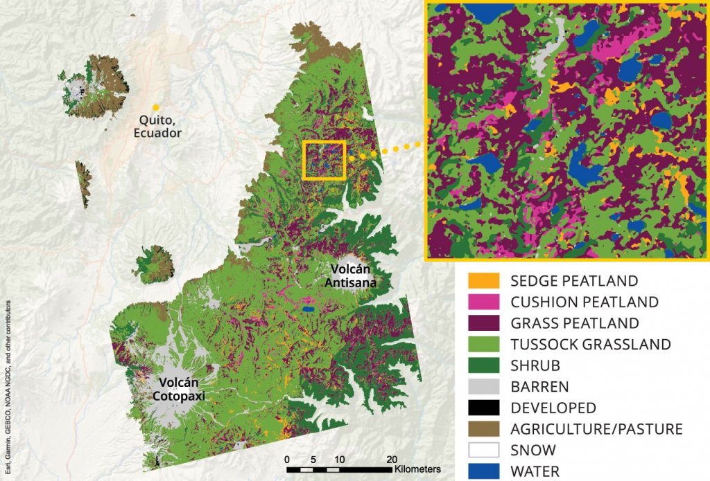
The improved maps show that, in Ecuador, half the landscape or more is peatlands, a significant increase over the Ecuadorian government’s estimates.
Bourgeau-Chavez confirms what a difference mapping has made to wetland management: “This was the first time someone has mapped the peatland alpine regions,” she says, noting that seasonal moisture patterns add complexities to the mapping. “In Ecuador, even the non-peatland areas are wet. If this mapping process works in Ecuador, it’ll work anywhere.”
Bourgeau-Chavez is beginning to map Peru next, but her efforts are not confined to the Andes. SWAMP is an exercise in collaborative science between researchers, governments, and people, with benefits, insights, and spatial management data shared across borders and continents.
“Now that the methods are developed, we are seeking to apply them in the US,” says Erik Lilleskov, research ecologist at the USFS’s Northern Research Station in Houghton, Michigan. “It’s a real positive for the USFS, because a lot of the federal lands in the American Rockies are high-elevation mountain peatlands as well.”
Mitigating
Mitigating the effects of climate change will require concerted, multinational efforts, so SWAMP emphasizes capacity building for local communities where the team samples.
"If you take care of the peatlands, not only do you have clean water, you're storing most of the carbon in the country. If you manage carbon, you're managing everything else."
“We’re training people to do leading-edge science in these countries to aid in their ability to manage these ecosystems more effectively,” Lilleskov says. “To the extent we can help other countries stabilize their environment, that allows them to thrive, and to be better partners of the US and the global community.”
SWAMP projects include workshops with local universities, government agencies, and nongovernmental organizations on how to core peat, measure carbon and methane emissions using trace gas and eddy flux measurements, quantify carbon stocks, and wetland ecology basics. Chimner takes people into the field to demonstrate how to build check dams to restore damaged wetlands and works with ranchers to adopt more sustainable grazing practices.
“We’re teaching them how to do this, so eventually they’ll take it over completely,” Chimner says, adding that several Ecuadorian and Peruvian students have completed graduate studies at Michigan Tech with the goal of taking their knowledge back to improve Andean peatland management.
Michigan Technological University is an R1 public research university founded in 1885 in Houghton, and is home to nearly 7,500 students from more than 60 countries around the world. Consistently ranked among the best universities in the country for return on investment, Michigan's flagship technological university offers more than 185 undergraduate and graduate degree programs in science and technology, engineering, computing, forestry, business, health professions, humanities, mathematics, social sciences, and the arts. The rural campus is situated just miles from Lake Superior in Michigan's Upper Peninsula, offering year-round opportunities for outdoor adventure.