Through its conservation programs the United States Department of Agriculture (USDA) Natural Resources Conservation Service (NRCS) deliver both technical assistance and funding to farmers to encourage farming and land management practices to conserve the natural resources which provide an array of ecosystem services.
Although some conservation programs have existed in their present form since 1985, the USDA has not conducted a formal evaluation of their effectiveness in meeting conservation goals and objectives, such as clean water and less erosion. To address this information gap, the USDA contracted with the MTRI to examine the ecological effects of NRCS programs retroactively and to develop a method for ongoing future evaluations. In addition, NRCS requested that MTRI develop and provide tools for improved communication and feedback to NRCS management. Outputs from this project, which started in 2003, are provided in the fact sheet and publications included on this page.
The Great Lakes contain 18 percent of the earth’s fresh surface water, a system with a surface area of 95,000 square miles and a watershed covering hundreds of thousands of square miles. The NRCS programs serve to improve hydrologic characteristics, water quality, and habitats in a number of Great Lakes watersheds. In Michigan, the NRCS manages five Farm Bill Programs. Managing these programs presents the challenge of maximizing the synergy of the programs while achieving the ecological benefits.
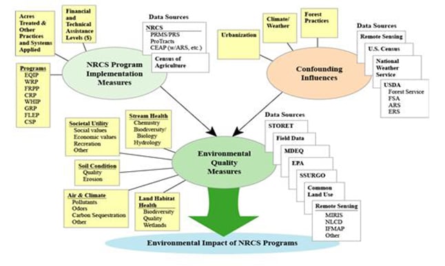
In the broadest sense, the primary goal of this project is to develop and apply a method for evaluating the environmental effects of NRCS’s conservation programs. Other goals include enabling improved communication of conservation-related information within and outside of the NRCS and providing better feedback to NRCS management so programs can be managed more effectively. In our first year of funding, we developed a prototype of the NRCS Environmental Quality Index (EQI), a metric for evaluating conservation program effectiveness. We further assisted the Michigan office of NRCS in program management by developing open source information tools to assess program implementations and benefits and to map the EQI for Michigan counties.
Development of remote sensing-derived measures and geospatial information products to help drive the EQI-based assessment of NRCS program effectiveness was the focus of a USDA-National Research Initiative grant to MTRI. Details and outcomes from this activity, “Using Remote Sensing-based Measures to Assess NRCS Program Impacts in Michigan” were available as the project reached its conclusion in 2009.