
What began as a stack of fragile, century-old mine maps is being transformed into an immersive 3D window into the past by archaeologists, energy policy experts and data scientists at Michigan Technological University.
One of the most promising frontiers of discovery isn't "out there" — it's beneath our feet. Under the forests and towns of Michigan's Upper Peninsula lies a vast, mostly forgotten world of tunnels and shafts, remnants of the region's mining heyday. Researchers at Michigan Tech are using computing power to bring that world and its possibilities back into view through a collaboration between Michigan Tech's College of Computing and College of Sciences and Arts (CSA).
Archaeologists and energy policy experts from CSA's Department of Social Sciences turned to data scientists in Computing[MTU]'s Department of Applied Computing to build digital models of old mines that preserve history while offering safer, more sustainable futures.
The visually striking models serve as research tools for evaluating energy storage potential, water flow modeling and mine safety assessments. Research aside, their potential applications stretch far beyond the iron and copper ranges of Michigan's Upper Peninsula.
From Pickaxes to Paper to Pixels
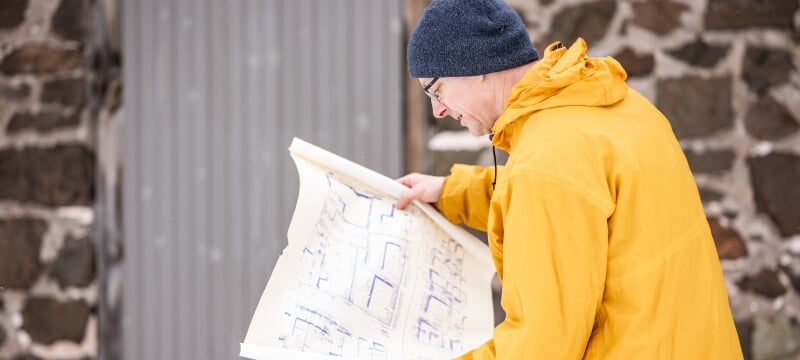
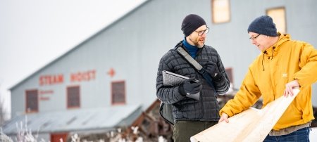
The initiative started with a challenge to turn hundreds of creased, stained and sometimes barely legible old mine maps into usable digital data. The prospect sounds overwhelming — and it certainly felt that way to Tim Scarlett, an associate professor of archaeology at Tech. Scarlett has spent decades studying the state's mining industry and examining the ways in which post-industrial communities can reclaim economic empowerment and retain their proud heritage. Knowing more about what lies beneath is crucial to the process. But converting historical archives into actionable data accurately and efficiently was beyond his expertise.
"I reached a point where I was stuck," Scarlett said. "I knew there was huge potential in these maps, but the tools I needed to get there — machine learning, computer vision, automated image processing — were outside my area. So I started making phone calls."
Scarlett didn't have to look farther than the Michigan Tech campus for answers. He connected with Ashraf Saleem and Nathir Rawashdeh, assistant professors in applied computing, who assembled a group of students in the mechatronics graduate program, and an interdisciplinary research team was born. The group is continuing to develop a semiautomated process to digitize, clean and reconstruct old survey maps. But the preliminary work is already yielding breakthrough results.
Headlamps On: A New Way to Look at Old Mines
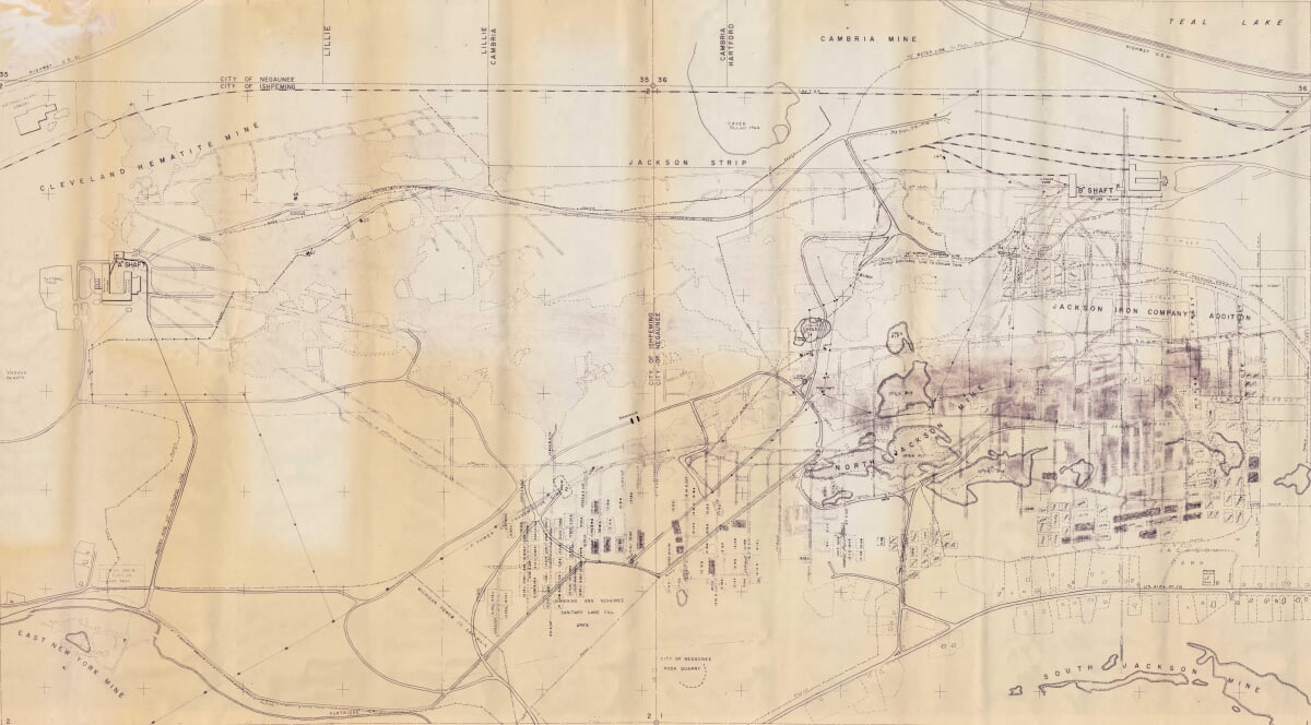
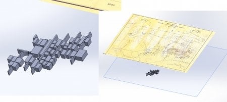
The team's first test case was the Mather B Mine in Negaunee, Michigan, which once fueled the Upper Peninsula's iron industry. Working with scans of delicate, century-old survey sheets, the team created algorithms capable of correcting distortions, enhancing contrasts and removing visual noise, including water stains, creases, gaps and faded ink.
Once cleaned, the images were stitched together, layered and transformed into a digital 3D model.
"Instead of hand-tracing every feature, we now have a pipeline that can handle much of the heavy lifting," Scarlett said. "The result is not just faster — it's clearer. It's a whole new way to see underground landscapes."
Rawashdeh said the process bridges computing, environmental data science and industrial archaeology in a tangible, actionable way.
"From a computing perspective, the challenge is immense," he said. "We're dealing with large image files, inconsistent handwritten data and fragile paper maps. But every improvement in automation brings us closer to scalable solutions that can be used for thousands of other mines worldwide."
At Michigan Tech, undergraduate and graduate students alike have played critical roles in the underground mapping project. Jacob Chizek '23 '25, who earned bachelor's and master's degrees in mechanical engineering, built the first 3D Mather B model. The current cohort of graduate student researchers includes College of Computing students Varun Kulkarni, Muntasir Khalifa, Omkar Samant, Balaji Nammalvar and Ayush Pharande, who have developed advanced image-processing modeling tools.
The team has turned what would have been a months-long exercise into a semiautomated workflow capable of producing detailed underground visualizations in just days. Scarlett is both grateful and impressed. "They're the puzzle solvers," he said. "I can describe the outcome we need, but they're the ones experimenting, writing the code and pushing the limits of what's possible."
Beneath the Surface
The underground mapping project is as much about discovery as it is efficiency. And its scope is global.
Scarlett, who is among the Michigan Tech researchers actively working on adaptive community solutions for mine reuse, said regions around the world are grappling with how to understand and manage abandoned mines as well as those that will be closed in the future.
At a 2024 conference on reusing abandoned coal mines, Scarlett heard how researchers in Pennsylvania and West Virginia have spent tens of thousands of hours manually reconstructing mine systems to predict how groundwater and acidity move through interconnected tunnels.
"Even the tools those teams have built could be accelerated by what our students have developed here," Scarlett said. "Just the digital cleaning and information extraction we've achieved would save an enormous amount of time — and that means saving money, too."
And for archaeologists like Scarlett, mapping the underground also opens the door to increased understanding of historical working landscapes that are now inaccessible.
"Imagine an early 20th-century mine where the last workers left footprints in the mud," Scarlett said. "Their tools, their art, even their handwriting on the walls — it's all still down there, preserved underwater. With the right technology, we can map and study those spaces safely, without sending people into dangerous conditions."
Computing Can Unearth Ancient Cultures
The implications of the technology being developed at Tech reach far beyond mining communities.
From the Mesolithic community of Doggerland to submerged Ice Age caves on the North Sea, archaeologists around the globe are using robotics and remote sensing to explore underwater cultural sites. The same principles behind Michigan Tech's modeling systems — 3D visualizations, pattern recognition and machine learning techniques — could reveal entire chapters of human history hidden beneath oceans, lakes and land.
Scarlett said that's what makes this kind of collaboration so exciting.
The visual results are also sparking public curiosity and conversation.
When the 3D model of the Mather B was presented to Negaunee residents, folks were fascinated. Mining heritage runs deep in the community. The aboveground section of the mine is now a part of Negaunee High School. Some retired miners at the meeting recognized the tunnels they'd once worked in. Others envisioned how 3D rendering could be used for outreach, from museum exhibits and school programs to interactive simulations or video games.
"People immediately started asking if we could 3D-print the models or make them virtual-reality walk-throughs," Scarlett said. "It's so much easier to grasp the scale of the underground when you can actually see it."
The team is already experimenting with an animated fly-through of the mines, and the future could include immersive educational experiences or interactive platforms where users explore historic sites digitally, blending heritage technology and storytelling in unprecedented ways.
The Road (or Tunnel) Ahead
As the semiautomated system continues to evolve, the team's next step is to integrate machine learning training algorithms that recognize patterns, align maps and build models with minimal human input. That will require additional computing power, research hours and continued support. Michigan Tech's culture of interdisciplinary collaboration and flexibility makes progress possible.
"Call it archaeology, applied computing, robotics — it doesn't matter. The outcome is the same: new knowledge and new capabilities. We all get something out of it. This is the kind of thing we want technology to do — not replace creativity, but remove the drudgery so we can focus on discovery."
"At Tech, we can just pick up the phone and make things happen," Scarlett said. "There aren't all these rigid barriers between departments."
Tech's support ecosystem also extends to donor partnerships. Alumni and friends, including gifts made to the Industrial Archeology Fund and the Keweenaw Energy Transitions Lab, have helped Scarlett and fellow researchers create student-driven projects like the 3D mine-mapping initiative.
"Donors have trusted us to do interesting things," Scarlett said. "They've given us the ability to be nimble — to see a great idea, get students involved and just run with it."
Whether it's for energy planning, historical preservation or ecological restoration, mapping the underground is a window into both the past and the future.
Michigan Tech's approach has sparked interest from agencies and research groups beyond the Upper Peninsula. The potential applications are as diverse and abundant as the thousands of old maps stored in repositories around the world. At Tech alone, researchers have collaborated on projects focused on adapting old mines for use as climate-controlled bat habitats, modeling geothermal systems, and repurposing abandoned shafts for pumped-hydroelectric underground energy storage.
For current and incoming Huskies, the enhanced ability to plumb the depths of the region's mining heritage will enable more impactful exploration, allowing them to conduct research that changes the world.
"Our students don't just learn to code or analyze data — they learn to think across boundaries," Scarlett said. "Projects like this teach them that technology can illuminate history, protect communities and inspire imagination all at once."
Michigan Technological University is an R1 public research university founded in 1885 in Houghton, and is home to nearly 7,500 students from more than 60 countries around the world. Consistently ranked among the best universities in the country for return on investment, Michigan's flagship technological university offers more than 185 undergraduate and graduate degree programs in science, technology, engineering, mathematics, computing, forestry, business, health professions, robotics, psychology, social sciences, humanities, and the arts. The rural campus is situated just miles from Lake Superior in Michigan's Upper Peninsula, offering year-round opportunities for outdoor adventure.
Comments