Report 1: An Accuracy and Agreement Assessment for Midwest Wetlands: An Example Using the St. Mary’s University NWI Update for Iowa
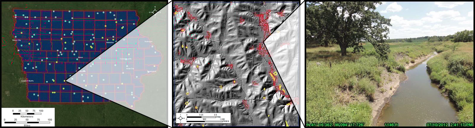
Based on Cowardin et al.’s 1979 report “Classification of Wetlands and Deepwater Habitats of the United States,”the National Wetlands Inventory (NWI) is a mosaic based on the best available data. In 2003 the Iowa Department of Natural Resources tasked St. Mary’s University of Minnesota with updating the original NWI for the entire State of Iowa. Using 2002 color-infrared imagery, St. Mary’s University created an updated (not remapped) version of the NWI. By request of the U.S. Fish and Wildlife Service, MTRI performed an accuracy and agreement assessment of St. Mary’s University’s analysis. This involved an in-depth geographic information system (GIS) analysis of 122 4 mi2 sites across the State of Iowa and field visits to some of the selected sites. In addition, MTRI also recommended and demonstrated the benefits of using additional data sets supplementing the color-infrared imagery. The full MTRI report titled “An Accuracy and Agreement Assessment for Midwest Wetlands: An Example Using the St. Mary’s University NWI Update for Iowa” can be found by clicking the link below.
Report 2: Improved Wetlands Mapping Methods: A Summary Report
Changes occurring in wetland distributions are important to study due to the fact that these areas are good indicators of potentially harmful changes occurring on the surrounding landscape. Having up-to-date information on the status of wetland distributions allows for conservation and management of wetland systems. There are many possible ways to assess a wetland system, which are often driven by the needs of the organization performing the analysis. The following six currently active wetland classification programs and methodologies are outlined in MTRI’s second report titled “Improved Wetlands Mapping Methods: A Summary Report.” This report can be found by clicking the link below.
- The Canadian Wetlands Classification System (includes Ontario Ministry of Natural Resources (MNR) Inventory)
- Ducks Unlimited/Equinox Analytics/Minnesota Department of Natural Resources (MNDNR) Wetlands Mapping
- Hyperspectral Wetlands Mapping Methods
- The Wisconsin Wetlands Mapping Program
- Electro-Optical Radar Fusion Methods (Bourgeau-Chavez)
- United States Geological Survey (USGS) Potential Wetlands Index Program.