Wildland fire is an important source of carbon and other pollutants to the atmosphere. Accurate datasets to spatially quantify carbon and trace gas emissions from fire are needed. Dr. Nancy French, of the Michigan Technological University, Michigan Tech Research Institute (MTRI) has teamed with specialists at the USDA Forest Service Pacific Northwest Research Center’s Fire and Environmental Research Applications (FERA) lab improve data and methods of quantifying wildland fire emissions by adapting existing Forest Service fire information products and tools using NASA data and products. This research has been underway since 2006, and has been sponsored by NASA’s Carbon Cycle Science Program, Carbon Monitoring System (CMS), NASA Applied Sciences Program, and the US Joint Fire Science Program.
The goal of the research is to develop improved products for modeling and estimating fire emissions and implement an information system for disseminating this information to end users and decision-makers within the US.
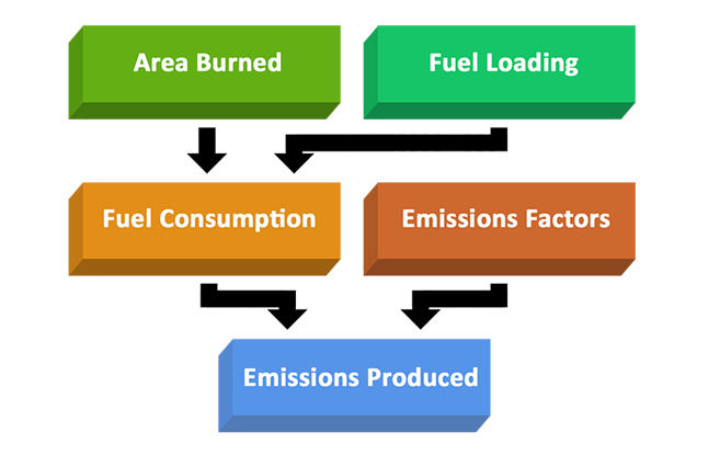
Estimating wildland fire emissions from ground-based data requires calculation from four parameters (Figure 1; French et al. 2004): area burned, fuel loading (biomass per unit area), fuel consumption (fraction of biomass consumed), and emission factors (mass of a given chemical species emitted per mass of fuel/biomass consumed).
Spatial Modeling of Wildland Fire Emissions Using the Wildland Fire Emissions Information System (WFEIS)
MTRI has developed an interactive, on-line geospatial information system that pulls together fire location data with corresponding fuel consumption and fuel loading data layers for fuel emission modeling. For complete information on project outcomes visit the Wildland Fire Emission Information System website.The geospatial data system is built from open-source software components that work with open international standards developed by the Open Geospatial Consortium (OGC) such as Web Mapping Service (WMS) and Web Feature Service (WFS) in order to facilitate future enhancements to the system. Updates to the system are ongoing with additional funding from the USDA Forest Service and NASA’s Terrestrial Ecology Program.
The information system provides access to data representing all four of the data layers needed for estimating fire emissions (see Figure 1). Information products are provided as GIS-based and tabular products at a 1-km cell-size covering the conterminous United States, and Alaska. The fuel loading maps have been improved for the US based on the procedure employed to map the conterminous US by Co-I McKenzie (McKenzie et al. 2007; McKenzie et al. 2012) Fuel consumption is estimated by employing the CONSUME fuel consumption model (Ottmar et al. 2007; Ottmar 2014).
The data products developed with WFEIS are useful for quantifying carbon emissions from fire (French et al. 2004; de Groot et al. 2007; French et al. 2007; de Groot et al. 2009), mapping emissions locations and source strength, and understanding the impact of wildfire smoke on human health (Thelen et al. 2013; French et al. 2014; Hutchinson et al. 2018). Several research projects at MTRI have used WFEIS in research into carbon and pollutant emissions.
Relevant Literature
de Groot, WJ, Landry, R, Kurz, WA, Anderson, KR, Englefield, P, Fraser, RH, Hall, RJ, Banfield, E, Raymond, DA, Decker, V, Lynham, TJ, Pritchard, JM (2007) Estimating direct carbon emissions from Canadian wildland fires. International Journal of Wildland Fire 16, 593-606.
de Groot, WJ, Pritchard, J, Lynham, TJ (2009) Forest floor fuel consumption and carbon emissions in Canadian boreal forest fires. Canadian Journal of Forest Research 39, 367 - 382.
French, NH, Koziol, BW, Powell, RB, Spaete, L (2007) Variability in fuel consumption across fire-effected boreal and western North American forest regions. Eos Trans. AGU 88(52), Fall Meeting Supplement, Abstract B14C-06.
French, NH, McKenzie, D, Erickson, T, Koziol, B, Billmire, M, Endsley, KA, Yager Scheinerman, NK, Jenkins, L, Miller, ME, Ottmar, R (2014) Modeling regional-scale wildland fire emissions with the Wildland Fire Emissions Information System. Earth Interactions 18, 1-26.
French, NHF, Goovaerts, P, Kasischke, ES (2004) Uncertainty in estimating carbon emissions from boreal forest fires. Journal of Geophysical Research 109, D14S08.
Hutchinson, JA, Vargo, J, Milet, M, French, NHF, Billmire, M, Johnson, J, Hoshiko, S (2018) The San Diego 2007 wildfires and Medi-Cal emergency department presentations, inpatient hospitalizations, and outpatient visits: An observational study of smoke exposure periods and a bidirectional case-crossover analysis. PLOS Medicine 15, e1002601.
McKenzie, D, French, NH, Ottmar, RD (2012) National database for calculating fuel available to wildfires. Eos, Transactions American Geophysical Union 93, 57-58.
McKenzie, D, Raymond, CL, Kellogg, L-KB, Norheim, RA, Andreu, AG, Bayard, AC, Kopper, KE, Elman, E (2007) Mapping fuels at multiple scales: landscape application of the Fuel Characteristic Classification System. Canadian Journal of Forest Research 37, 2421-2437.
Ottmar, RD (2014) Wildland fire emissions, carbon, and climate: Modeling fuel consumption. Forest Ecology and Management 317, 41-50.
Ottmar, RD, Sandberg, DV, Riccardi, CL, Prichard, SJ (2007) An overview of the Fuel Characteristic Classification System (FCCS) - quantifying, classifying, and creating fuelbeds for resource planning. Canadian Journal of Forest Research 37, 1-11.
Thelen, B, French, NHF, Koziol, BW, Billmire, M, Owen, RC, Johnson, J, Ginsberg, M, Loboda , T, Wu, S (2013) Modeling acute respiratory illness during the 2007 San Diego wildland fires using a coupled emissions-transport system and general additive modeling. Environmental Health 12, 94.