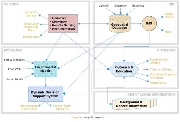
The Great Lakes Environmental and Molecular Sciences (GLEAMS) Center, funded by the Environmental Protection Agency (EPA), addressed the effects of urban, industrial, agricultural, and other non-point source pollution on the Great Lakes through investigations conducted on multiple spatial and temporal scales. The Center was established as a collaborative venture between Western Michigan University's Environmental Institute and the Michigan Tech Research Institute (MTRI). GLEAMS focused on the Kalamazoo River watershed in Michigan as the primary watershed of interest, which is an EPA-designated Superfund site due to high concentrations of Polychlorinated Biphenyls (PCBs) in this watershed. The Center created a unique interdisciplinary web-based portal to address the Kalamazoo watershed. The Portal provided a one-stop-shop for the Kalamazoo Superfund site, by facilitating public access to environmental data, enabling collaboration among stakeholders, highlighting new scientific developments for ecosystem health characterization, and providing simplified interfaces for complex scientific models. GLEAMS is also currently expanding to include PCB modeling for the lower Fox River, Wisconsin, and for modeling additional contaminants such as mercury.
Portal Characteristics
A unique interdisciplinary web-based portal was created for the Kalamazoo watershed, which integrated environmental chemistry, molecular biology, remote sensing, and geospatial information technology. The GLEAMS Portal included dynamic, automated updates, and used baseline data sets, including bathymetry, river discharge rates, bottom type, contaminant levels, and flora and fauna species. The Portal also had appropriate models available for the river, including river hydrodynamics, fate and transport, food web relationships, chemical contaminant to gene expression and appropriate health advisories.
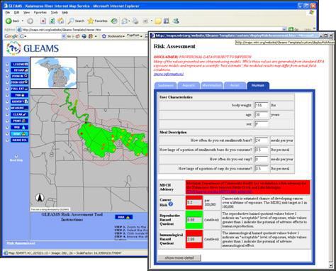
Risk Assessment Tool
The Risk Assessment Tool calculated appropriate risk and hazard quotients to ecological and human receptors based on standard EPA models that had been implemented for the Kalamazoo River watershed. While risk assessment reports typically assess risk for a limited number of target user groups and for a limited number of contaminated regions, the risk tool allows the user to select a specific location within the watershed and enter specific consumer characteristics to allow for a more accurate assessment of risk. The consumer characteristics that can be specified include: body weight, age, gender, and fish consumption habits. Based on the estimated PCB contamination for the location specified by the user and the entered consumer characteristics, the risk tool produces a color-coded assessment of risk for cancer, immunological health, and reproductive health. The risk assessment page also includes links that describe the implemented EPA equations and intermediate calculations. The risk tool also assessed ecological risk for many aquatic, mammalian, and avian receptors that live in the Kalamazoo Watershed. Although not shown in Figure 2, the ecological assessments were accessed for the same location by selecting the appropriate tab to the left of the ‘Human’ risk assessment tab.
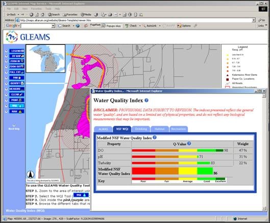
Water Quality Index (WQI) Tool
The Water Quality Index (WQI) Tool calculated an index of water quality for a particular use. The Index is single value that summarizes many different water quality parameters. Mathematically, the Index is an arithmetic weighting of normalized water quality measurements. The normalizations, as well as the weightings, are varied for different water uses. The National Sanitation Foundation (NSF) uses a WQI based on nine water quality parameters to monitor the quality changes in a particular water supply over time (NSF, 2006). The WQI Tool in the GLEAMS DDSS is based on physical and chemical measurements obtained from the ALWAS sensor platform, a free-floating data collection system that has been deployed in the Kalamazoo River.