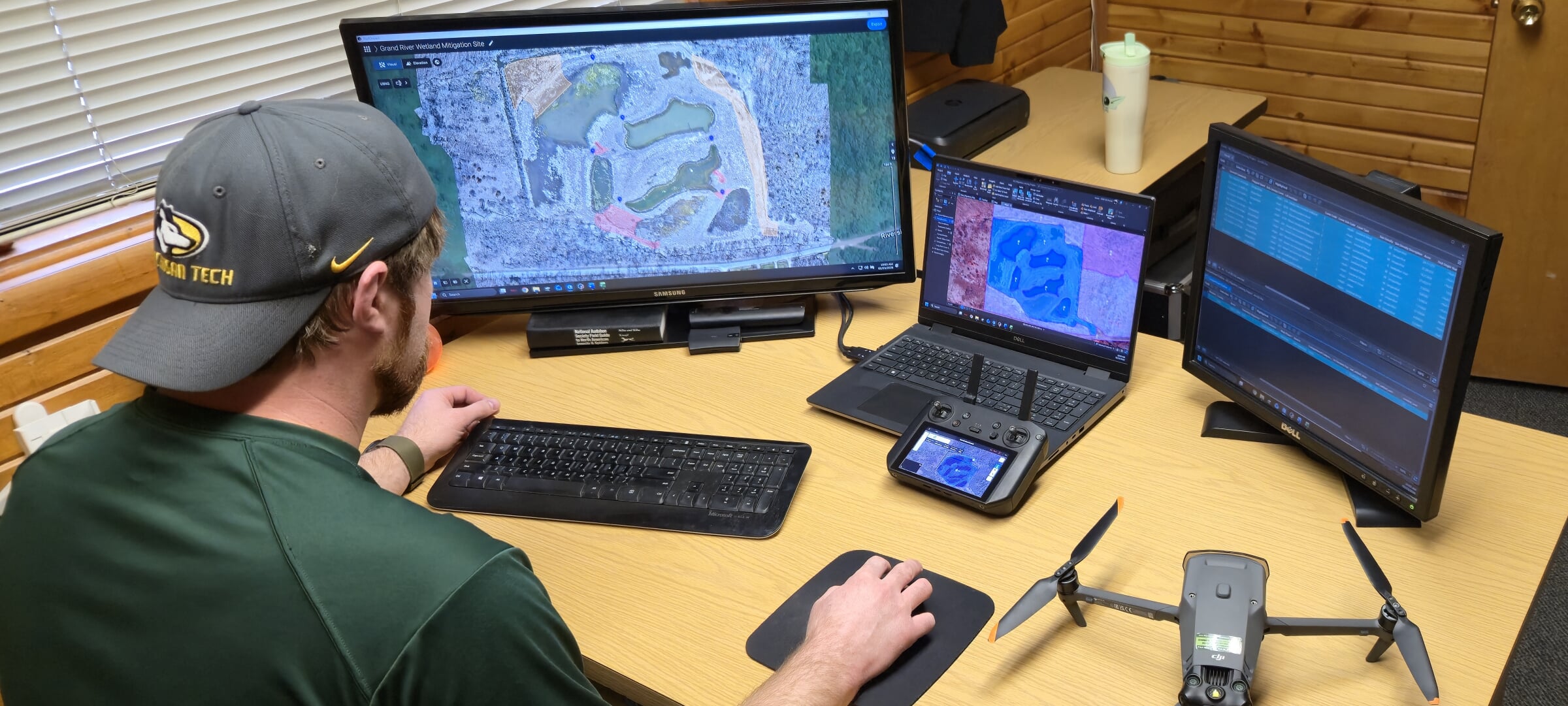
After getting real-time imagery of a site from a drone, James Miller creates an orthomosaic map.
From Fieldwork to Future Growth: How One DNR Biologist Advanced His GIS Skills Online.
Going back to school, especially graduate school, hits a little harder and life gets a little tougher when you have a full-time job, a mortgage, and two kids. And your “homework time” often starts after everyone is asleep.
That was James Miller’s reality when he went back to school more than ten years after finishing his B.S. in Fisheries and Wildlife Management at Lake Superior State University.
A seasoned wildlife habitat biologist with the Department of Natural Resources for the State of Michigan, James already had developed a niche: a passion and a talent for Geographical Information Science. In his office, he was the go-to subject matter expert and enthusiastic helper when it came to anything GIS. But he wanted to build on that role by applying his skills in a more practical way, while also becoming a better data steward and learning techniques that would improve his efficiency.
So he enrolled in Michigan Tech’s Foundations in Geographic Information Science for Natural Resources Certificate, completing it in December 2025.
He was able to fit coursework into the rhythms of real life thanks to the program’s online, asynchronous flexibility; the support of the Michigan DNR; and—most importantly—the steadfast encouragement of his family. James was especially quick to credit his partner, admitting that “without the amazing support from my spouse, I never would have had the confidence to go back to school.”
Thanks for agreeing to answer a few questions, James. When and how did you hear about MTU's Foundations in GI Science Certificate?
A supervisor in my division ran into Dr. Bhatt at a conference and heard about the program. That supervisor brought up to a colleague of mine that the program was looking for natural resource professionals who were interested in advancing their skill set in GIS. I then reached out to Dr. Bhatt to discuss the opportunity and was accepted into the program.
What was your original reason for pursuing this certificate?
I have worked with the Department of Natural Resources for ten years. GIS is something that has always interested me. Having some introductory skills in GIS after college, I saw that skill set as a very valuable tool to help me learn about the areas I managed and a great way to document and promote the work we do on state-managed lands. I took a lot of time to develop more skills in real world applications and discovered I had a knack for the work.
What did you like the most about the classes, the assignments, the instructor? What was your favorite course?
The courses being online and asynchronous allowed me the flexibility of being able to be with my family and handle my everyday life while still being able to go back to school successfully.
Dr. Bhatt is incredibly passionate about the work he does and brings excitement to a subject that many have a hard time connecting with. His energy and enthusiasm help keep students engaged while his approachability makes you feel comfortable asking questions and having open discussions when you're confused.
FW5550 - Geographic Information Science and Spatial Analysis was my favorite class within the certificate. Learning to be able to create my own digital elevation models, hillshade models, as well as being able to derive a full watershed analysis from that data was really fun. I was challenged weekly and the assignments all had real world applications.
Provide a brief description of a typical day at work. What are your main responsibilities?
If I were to describe what I do into a single sentence, I would say that my job is to create and enhance wildlife habitats to promote daytime hunting and viewing opportunities--both through an ethical conservation lens. Every project I move forward with is designed to have a positive impact on local wildlife, both game and non-game alike. My tasks are broad, but I try to be in the field using multiple GIS tools as often as I can. For example, within the last 1.5 years, I have started using maps as both project plans and as ways to communicate to my team the work I want to them to accomplish on the ground.
That is, I often start by looking at our GIS inventory of an area that I am looking to implement a project within. This first look allows me to analyze soil types, forest or grassland structures and many more components of the land. Then, I can decide whether or not the project will succeed in the selected area
Once I have a general idea of the area, I will go out and gps varying features that will be important to the project (i.e. Identifying and documenting openings in oak barrens sites that I want to implement a mowing and prescribed burn program into to promote a healthy Karner blue butterfly population).
I will then create a project map describing to my team what my expectations are, the work that will be completed within each mapped location, the windows of when the work can be completed, and an explanation of why the work is being completed.
These maps have QR codes that are linked to a georeferenced version of the map, so my team can follow the boundaries and guidelines I put in place.
In my current working-out-of-class role as the MDNR Wildlife Division GIS specialist, my day to day is managing my divisions GIS master layers and helping develop products to enable staff to have a more efficient and user friendly experience with division GIS tools.
This role is pretty new still; I am mostly doing data migrations at this point as we are changing to a new system.
Wow, that is an impressive and detailed process! How were you able to apply the skills, knowledge, theory, and so on, from the coursework to your current job?
Even though I had worked professionally with GIS tools for over 10 years, with this certificate, I was able to learn ways to make my work more efficient and of a higher quality. For instance, the training in the appropriate aesthetics in cartography has made my products look more professional. Being able to analyze digital elevation models has also helped me locate much more subtle variations inside of my management areas. With time and funding becoming more and more scarce in the professional workforce, the ability to complete projects faster and have them be of a higher quality has been extremely rewarding.
Did this certificate help open up new opportunities and/or responsibilities in your current role? If so, explain.
Back in mid-December, I was approached by supervisors who knew of my GIS interests and skills, and that I was in the Foundations Certificate to do a special assignment in helping to convert a few Wildlife Division authoritative datasets (Master Layers) into our new enterprise geodatabases. These are statewide datasets that are managed by my department. They were impressed with the work I did and I was offered a working-out-of-class position for the next year as the DNR Wildlife Division GIS specialist. Without the skills I developed and practiced during the Foundations Certificate, this opportunity might have not come up.
"Overall, Dr. Bhatt and his classes have helped me become a more well developed wildlife professional."
Great news and a deserved promotion! Last question: Are you taking any more online GIS certificates from CFRES? If so, when?
I am currently enrolled in the Advanced Geographic Information Science for Natural Resources Certificate. I am hoping to finish that this Fall and then take on the last certificate in the series (Remote sensing) in 2027.
Is there anything else you'd like to add? Any final words to share?
The program has been a great opportunity for me to expand my knowledge and open new doors within my career path.
GIS is an incredible tool to have in your belt when it comes to organizing, planning, and overseeing field work. It can have a large impact on how the public views an agency or business.
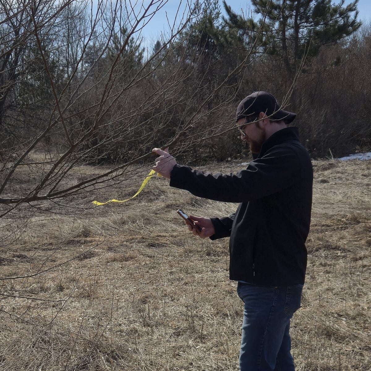
James Miller sets field markers and takes GIS points for spot chemical treatments.
Start Studying GIS for Natural Resources at MTU.
James’s story is a powerful reminder that going back to school as a working professional is not easy—but it can be deeply worthwhile. With support from family, guidance from dedicated faculty, and a program designed for real life, he was able to strengthen his GIS expertise, grow professionally, and open new doors within the Michigan DNR. His experience also demonstrates what can happen when motivated professionals pair real-world experience with targeted, flexible graduate education.
Michigan Tech’s online GIS certificate pathways, offered through Global Campus, can support both immediate career impact and long-term professional growth. Beginning with the Foundations in Geographic Information Science for Natural Resources certificate, and continuing through the Advanced GIS and Remote Sensing certificates, learners can build practical, career-relevant skills they can use right away.
Want to also boost your career by learning some versatile GIS skills? You can get started as early as Summer 2026 with FW5554, GPS Field Techniques, one of the core courses for the Foundations in GIS certificate. FW5554 is also offered in Fall 2026.
Also available for Fall 2026 are the following courses:
- FW 5550, Geographic Information Science and Spatial Analysis (4 credits, part of the Foundations certificate)
- FW 5553, Python for Modern GIS (3 credits, part of the Advanced GIS Certificate)
Learn more about other GIS certificates and reach out to Dr. Bhatt with your questions.
- Advanced GI Science for Natural Resources
- Remote Sensing for Natural Resources
- Contact Program Director Dr. Parth Bhatt
Level Up Online at Global Campus.
Whether you are looking to develop a focus area, expand your responsibilities, or prepare for what’s next, Michigan Tech’s online certificates offer a flexible and meaningful path forward for professionals who want to build expertise, grow in their careers, and add value to their roles. And don't worry if you've been out of school for awhile; the average age of Global Campus students is around 33! Even better: non-traditional students not only have advantages but also bring a lot of strengths to the classroom.