
The rocks of the Keweenaw Peninsula are ancient: More than one billion years old, containing loads of native copper deposits. Mining them created a legacy seen throughout the region.
The nation's first big mining boom certainly left its mark on the peninsula. It left icons like the Quincy Mine Hoist; it left massive deposits of mine waste, a fine material called stamp sands, outside Gay; it left a few problems, like a Superfund site in and around Torch Lake. As rich as the copper that people once mined here, the history of the Keweenaw is full of stories, insight, dilemmas, and opportunities. Call it geoheritage.
As part of ongoing geoheritage education, the annual Geotours are an effort to bring the earth processes and cultural legacy of the land to light. The program is run by Bill Rose, a professor emeritus of geology at Michigan Tech, and Erika Vye, a recent PhD graduate of the geology program. On Thursday, July 28, they took a boatload of people to the eastern side of the peninsula for an up-close and personal view of the Keweenaw's industrial mining legacy.
Mining History
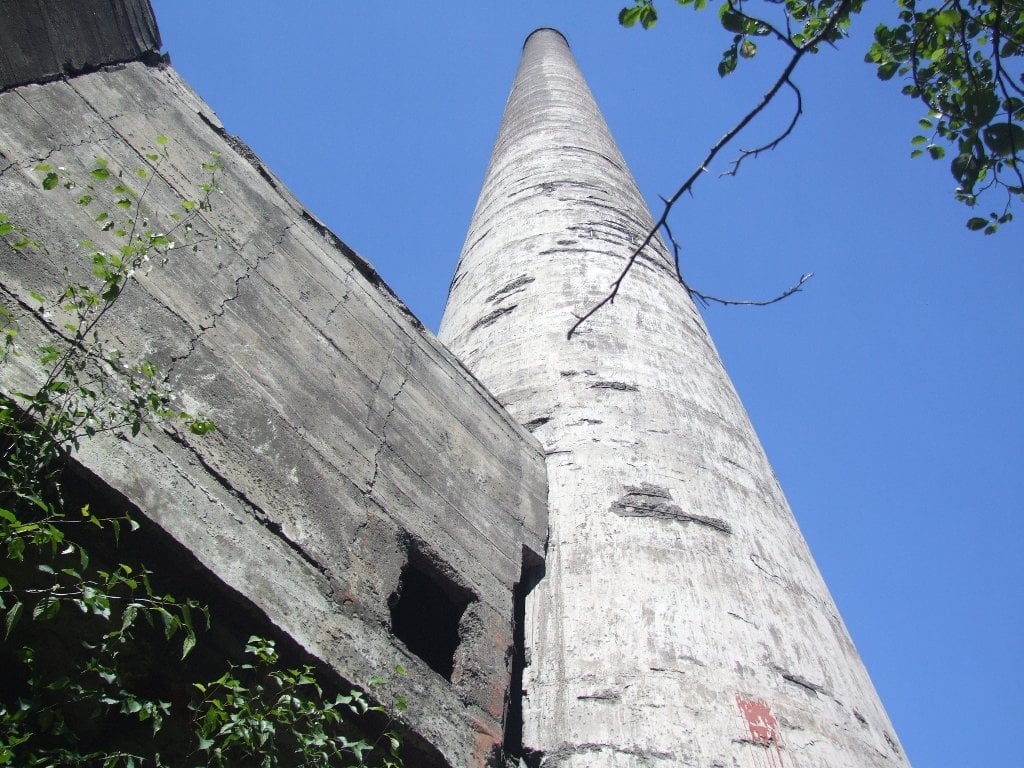
The stamp sands stretch on and on. They're the gray of water left in a mop bucket. The grains—as fine as any sand beach—are dusty and sparkle; the shimmer comes from tiny bits of arsenic minerals, found only at the Mohawk Mill site. A 236-foot tall smoke stack cuts a long shadow, crisscrossed by old wood frames and building foundations. Nearby, a few aspens and invasive weeds make small islands by the road. Very little grows elsewhere. Nothing separates the millions of tons of stamp sands from Lake Superior's waves crashing against the beach.

Stamp Sands Drone Footage or Drone's View of the Keweenaw's Mining Legacy
The water was a big reason this location was selected for the Mohawk Mill.
"You need a lot of water and a lot of rock to process copper-bearing rocks; you need a big lake or river," says Sean Gohman, a PhD candidate studying industrial archaeology at Michigan Tech.
He explains that for the copper rush here, which started in the 1840s and continued on for more than 100 years, many mines dug into the spine of the peninsula while processing facilities, like the early 20th century stamp mill here, strategically straddled the Lake Superior shore. This is one site of dozens where the basalt rock of the region—containing trace amounts of heavy native copper—was transported by rail, then pounded and stamped into sand, separated by density, and flushed away into the lake. Totaling about 22.7 million tons, the stamp mill was clearly a productive one.
"I think that stamp sands need to be appreciated, some could even be preserved," Gohman says. "We're lucky to have this here, it's the reason our communities exist."
That is the crux of geoheritage: It's not a judgment of good or bad history, it accepts the pride, complexity and challenges of a mining legacy. Standing on the stamp sands outside Gay, with dust puffing up from the tour group's feet and arsenic-rich mohawkite glittering for miles downshore, it's hard to ignore the sense of awe at the enormity of the mining enterprise that created the Copper Country. It's also hard not to cringe, at least a little.
"The adjectives you use to describe this area depend on your perspective; I say spectacular but others might say appalling."Bill Rose
What's difficult is accepting the nuance. This is a complex system with no real right or wrong answers—heck, it's hard to know what are the right questions. What is readily apparent is that the stamp sands have an impact. In terms of research, it's a matter of figuring out just what that is.
Aboard the Agassiz
Seeing patterns is easier from the water.
The R/V Agassiz, the university's research vessel at the Great Lakes Research Center is moored in Grand Traverse Bay's Schoolcraft Township Marina, almost 5 miles from the Mohawk Mill site. On one side of the harbor, the pink and white sands of the bay's natural beach stretch out; on the other side, stamp sands fan over the breakwater. The cascade of gray-black mine waste shows how the lake's currents keep pushing the sands along.
"Lake Superior doesn't like deltas, there's just too much wind and current so they get destroyed," Rose says, explaining that the lake is a highly dynamic environment that won't keep the stamp sands at rest. "So, the sands get carried away and they encroach on other areas—and it's all moving."

The R/V Agassiz goes surprisingly fast. A rocket compared to the longshore drift that has dribbled the stamp sands from their original location. In satellite imagery, the Gay stamp sands appear as a long, dark strip coating the shoreline. From the boat, that strip stretches on until it's too hazy to see the beginning or end. Underneath the boat, the sands tumble far out into the lake. As they are carried by storm waves and sifted by regular ones, the grains settle into the cracks of larger stones and cobbles. Swimming at a rocky beach, if you stick your ears into or just close to the water, then you can hear the crystalline cracks of the rocks as the waves shift them. The gentle rise, settling, and migration of the stamp sands is silent.

The boat quiets as Captain Stephen Roblee slows and lets the waves rock the tour group. He points to the depth monitor on his screen where two oval humps loom up under the water. Looking over the boat's side, as the vessel dips into a wave trough, the ghostly outlines of boulders waver about 10 feet below.
"We're right above the Buffalo Reef," says Casey Huckins, a professor of biology at Michigan Tech, explaining that "reef" refers to a high spot in the underwater landscape. As the boat sloshes again, he adds, "This is an important breeding spot for lake trout and whitefish."
(Quietly, one group member leans to her companion, "What's your sign, baby?" "Aquarius," he replies.)
Driven less by the Zodiac and more by natural instincts, Huckins says the cold-loving fish seek out reefs to lay eggs because the piles of cobbles and boulders protect the little orbs from wave action and predators. Growing up, lake trout juveniles favor the deep, open side of the reef and whitefish juveniles stick close to the shore side.
With stamp sands, the whitefish are hard to find hanging out by shore. Farther south and east, past Grand Traverse Bay, plenty of whitefish juveniles swim in shallow waters.
"This raises questions about what environments the fish can tolerate," Huckins says, explaining that copper is particularly toxic to fish. "We haven't studied it enough yet and we need to."
The boat passes the reef and flies back to the harbor. The contrast between the blue waves, black sand, and red sandstone seem so stark—the colors are so separate and it feels like nothing can be done to hold back the mine waste's march. In Torch Lake, though, people did try to make a difference.
Superfund
Pairing the word "lake" with Superior is a misnomer. Lake Superior is really a sea. And squeezing through the narrow outlet into Torch Lake makes that readily apparent. With crowded shorelines thick with trees the green of a well-watered suburban lawn, Torch Lake defies space and time. It feels like the epitome of any Midwestern lake on any summer day, complete with lakeshore docks and fancy homes.
But the trees and cabins are deceptive. This is a dead lake.

The benthic community doesn't exist here. That is, there are few to none of the normal organisms that live on or in the lake bottom sediments. That entire portion of the bottom-dwelling food chain—a big part of the supportive foundation—is missing, making higher levels less stable. It all circles back to the photosynthesizing base of any food chain.
"The geology and geological processes determine what plants and plant communities can grow in a place," says Jill Fisher, a staff member at Michigan Tech and an ecologist by training. "So understanding the first helps you understand the second better."
And in Torch Lake that means understanding what happens when half a lake is filled with stamp sands and used as a dumping ground for industrial waste. The Environmental Protection Agency (EPA) declared the lake a Superfund Site in 1986. Unlike in Lake Superior, where sediment is pushed around and dispersed, the Torch Lake sands stay put. The remediation goal is to wait for the contaminated sediments, as fine as flour dust, to get buried with time. However, some contaminants—like mercury—do not stay put.

To help secure the lake, particularly the shoreline where the most erosion occurs, the EPA laid down topsoil. Mostly invasive species like knapweed and bird's foot trefoil have taken over, but any and all roots do help stabilize the soil, creating a cap on the stamp sands.
The Torch Lake expert aboard the R/V Agassiz is Carol MacLennan, a professor of anthropology at Michigan Tech. She's been around a few Superfund sites and remarks on the hidden nature of this one as the boat passes Lake Linden's waterfront.
With its rusted metal, dark windows, and grayed lumber, the old mill and electrical powerhouse look like the raw materials for an industrial chic desk. And with the charming parks and sandstone downtown, some might be fooled into thinking the town's waterfront is cute. MacLennan points to the water's edge along a dilapidated pier where dozens of drowned barrels are suspected to be oozing significant contaminants. Testing remains ongoing to determine what exactly may be leaking out.

"The lesson about mine waste? You have to learn to live with it—and what does that really mean?" she asks. "With all mining and processing sites, we look at the risk of human and environmental harm. Those aren't always things we can readily see."
The boat rounds a point, revealing a white and brick mansion topped with a large American flag, whitewashed deck, and matching dock below. Farther beyond, past a couple fields of purple and yellow fields of remediated land, a campground juts out into the lake.
Delisting the Torch Lake Superfund sites began in 2004; it now counts as one of 347 delisted sites among the 1,652 Superfund sites managed by the EPA. The Michigan Department of Environmental Quality still lists the lake as an Area of Concern and recently initiated site-specific soil testing to identify additional contaminated areas.
Referencing the interdisciplinary research of faculty at Michigan Tech and the agencies, MacLennan says, "As a result of this collaboration, we've been able to dig into problem areas that the state and federal agencies have not yet addressed."
What drives most people's involvement in remediation is the care they have for their communities and history. Rose says he knows where to start.
The Next Generation
Caring about community and history can take root in a classroom.

"Teachers are multipliers, but they are also learners," Rose says, turning so that the light catches on a sprig of St. John's Wort in his hatband. "So having teachers involved on our tours ups the level of our work for youth, who are our salvation."
A handful of teachers came aboard the R/V Agassiz; they disembarked with new ideas to weave into their classes.
"Incorporating local history is hard in light of the state's strict requirements for content standards—none of which talk about the history up here," says Melissa Schneiderhahn, a local teacher. She and other teachers make do by designing lesson plans that use the framework of state's base requirements, modified to accommodate local information and field trips that help explain past cultures, basic chemistry, the food chain, and other scientific and historical concepts. The Keweenaw National Historical Park teams up with local teachers, after school programs, and Michigan Tech researchers to bring history and science together.
"The key to engaging kids is starting with a cool place and what's cooler than this? It's right in our backyards." Melissa Schneiderhahn
Michigan Technological University is an R1 public research university founded in 1885 in Houghton, and is home to nearly 7,500 students from more than 60 countries around the world. Consistently ranked among the best universities in the country for return on investment, Michigan's flagship technological university offers more than 185 undergraduate and graduate degree programs in science and technology, engineering, computing, forestry, business, health professions, humanities, mathematics, social sciences, and the arts. The rural campus is situated just miles from Lake Superior in Michigan's Upper Peninsula, offering year-round opportunities for outdoor adventure.


Comments