

Numerous Michigan Tech alumni and faculty are part of the response and research effort on Hawaii’s Big Island.
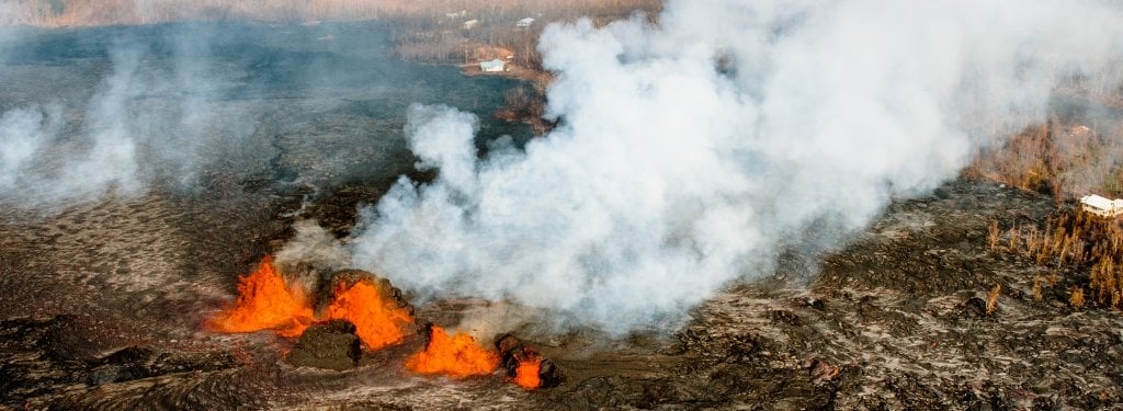
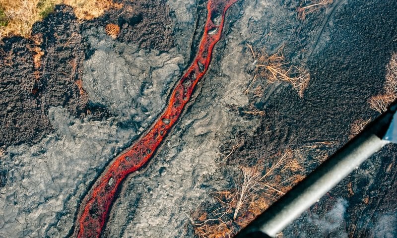
Volcanoes are an ongoing source of fear and fascination for humanity. The heat and destructive power are both harbingers of destruction and heralds of creation. Kīlauea, Hawaii’s youngest and the world’s hottest volcano, has been erupting constantly since 1983, but in the past month the eruption has grown exponentially in size and power.
Alumni, past post-doctoral researchers and faculty have all played a part in the Kīlauea eruption response, including Greg Waite, John Lyons, David Schneider, Verity Flower, Tricia Nadeau, Jay Wellik and Matt Patrick.
The volcano’s eruption has been called a once-in-a-generation opportunity for scientific research, but it has also been hugely disruptive and damaging to communities and area tourism. The volcanologists, geologists, geochemists and other scientists who have been called to Hawaii’s Big Island are there to aid the state’s emergency response team. They are also there to research volcanoes to improve future eruption response. Many of these same people are now being called upon to assist with response to the June 3 Volcán de Fuego eruption in Guatemala.
Response
Greg Waite, associate professor of geological and mining engineering and sciences, was on sabbatical at the Hawaiian Volcano Observatory when the shield volcano began erupting with increased intensity.
“I came out here with some research projects in mind and I’m still hoping to complete those projects, but when the eruptions started and activity really picked up at the end of April, I became more involved in day-to-day monitoring as well,” Waite says.
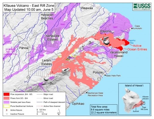
Heeding the call from USGS, geologists are in the field—especially the rift zone where explosive eruptions are occurring—around the clock. While the majority of the rift zone is in the national park, which is closed, the situation is different in the lower east rift zone where fissures are opening up in neighborhoods.
“Some homeowners are waiting until the last minute to leave their homes as lava approaches. First responders are waiting for USGS to provide updated information so they can plan for evacuations,” Waite says. “It’s dynamic; changing from day to day. It requires a lot of people to keep track, taking part in watch shifts all hours of the day and night.”
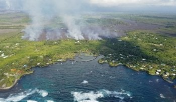
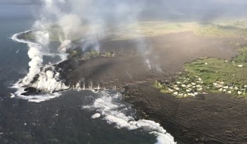
Responders are essentially reacting to two different eruptions—explosions and gas emissions. Ash is hazardous to aviation and health, as is sulfur gas emissions. Both air quality and encroaching lava create ongoing threats to private property and infrastructure, including a geothermal electric plant and cell phone towers.
David Schneider, who earned his doctorate from the Department of Geological and Mining Engineering and Sciences at Michigan Tech in 2000, is a research geophysicist for the US Geological Survey (USGS) at the Alaska Volcano Observatory, and was deployed to Hawaii to help assist with disaster response at the request of the Federal Emergency Management Agency.
“This is an eruption that has posed significant and widespread impacts to local communities. When large events happen there aren’t enough staff at any of the five USGS volcano observatories to handle the situation. We get deployed to help out each other,” Schneider says.
Schneider’s expertise is in volcanic ash and explosive eruptions. He’s one of 15 USGS scientists from the mainland who have been brought to Hawaii to help with the eruption response.
Schneider has been working with the Hawaiian Emergency Management Agency (HI-EMA) in its emergency operations center located at Diamond Head on the island of Oahu. He works within a large team of state and federal emergency management specialists to provide near-real-time information from the scientists involved in eruption response to HI-EMA and the Hawaii Governor’s Office. He also works with state and federal agencies and public health officials to discuss hazard mitigation from sulfur dioxide emissions and ash-rich explosions.
“We answer questions throughout the day and try to take some of the scientific information and explain in a way that makes sense to non-volcanologists,” he says.
The incredible amount of data scientists are grappling with presents its own problem; processing data from sensors, satellites and other measurements takes teams of people to create knowledge from information and apply it to a rapidly changing situation.
Schneider speculates that the application of the knowledge regarding lava hazards may have had some unintended consequences for people living in the lower east rift zone.
“In 1992, the USGS published a lava flow hazard map detailing the five hazard zones on the island of Hawaii. It may be that these lava hazard maps, which were important to publish, may have actually contributed in some way to people living there because it made that property more affordable,” he says.
Hawaiian real estate is infamously expensive, and neighborhoods like the Leilani Estates were affordable to working-class residents, who frequently couldn’t get mortgages or homeowners insurance on the houses because of their location in the highest lava hazard zone. But the building sites were reasonably priced, so area residents took a gamble to secure affordable housing.
“By having scientists say this is a dangerous place, the economic side of things was that property was more affordable,” Schneider says. “All over the world people with fewer means end up living in the most hazardous areas. People get pushed into places economically they wouldn’t necessarily choose to be. It remains to be seen to what extent publication of hazard zone maps may have played in the development of the region impacted by lava flows, but it is a topic that deserves further research.”
Schneider said that while the research opportunities at the eruption are exciting, the scientists feel sadness for those who have lost their homes to the lava flow.
Research
The Kīlauea eruption is more than lava fountains and ash clouds. Volcanoes are part of complex geophysical systems, and those who research them seek to learn more about how the systems interact. Kīlauea is particularly complex. It is erupting from two areas that are 25 miles apart and the stresses within the crust at the different eruption sites are also influenced by the magnitude 6.9 seismic event the Big Island experienced May 4.
“Earth scientists in general think a lot about processes,” Waite said. “We don’t think of the Earth as a static body. This is a very complicated system underneath Kīlauea that takes people with many specialties working together to understand what’s happening and how things are changing to try to determine what happens next. It’s amazingly interesting trying to figure out what’s going on and watching this unfold in real time.”
Waite researches magma movement and gas emissions through the lens of seismic and infrasound (low frequency sound) data. In fall 2017 he set out an array of infrasound sensors at the crater of Kīlauea‘s lava lake to “hear” the volcano because most energy they radiate into atmosphere is below a frequency humans can hear.
“I got some really good data in the fall and early on this year from arrays in good locations,” Waite said. “With the USGS’s permanent seismic network, those showed clearly the main source of the tremor was degassing at the lava lake. We could track very clearly where the gases were coming out of the lava lake from the infrasound.”
Unfortunately, in the past month the sensors have stopped working, likely because the solar panels that provide them power are covered in volcanic ash, and it’s too dangerous for Waite to dust them off, given their proximity to the expanding crater.
Waite says that at this point the volcano doesn’t show signs of slowing. Since 1983, the overall eruption has periodically increased and decreased given a deep supply of magma in the Earth’s mantle below the volcano. As long as that supply continues, so will the eruptions. Waite said there could be periods of lower activity for years or even decades, but the eruption will resume and continue until the Pacific tectonic plate moves Hawaii island off of the mantle hotspot and a new volcano south of the island becomes the focus of eruptive activity.
In the meantime, Michigan Tech’s geological engineering program will continue to produce volcanologists to study these volatile and important features of Earth’s geophysical system. The sheer number of people affiliated with Tech responding to the situation is proof of that.
“The volcano community is small,” Schneider says. “There are not that many places to study volcanoes in the world. There are only a couple thousand volcanologists in the world; you know most everybody.”
Michigan Technological University is an R1 public research university founded in 1885 in Houghton, and is home to nearly 7,500 students from more than 60 countries around the world. Consistently ranked among the best universities in the country for return on investment, Michigan's flagship technological university offers more than 120 undergraduate and graduate degree programs in science and technology, engineering, computing, forestry, business, health professions, humanities, mathematics, social sciences, and the arts. The rural campus is situated just miles from Lake Superior in Michigan's Upper Peninsula, offering year-round opportunities for outdoor adventure.

Comments