
There is no mint that can take the edge off sulfurous emissions from volcanoes, but researchers can use remote sensing to better understand volcanic breathing.
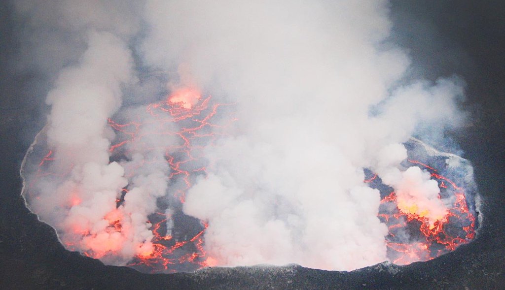
Volcanoes erupt, they spew ash, their scarred flanks sometimes run with both lava and landslides. But only occasionally. A less dramatic but important process is continuous gas emissions from volcanoes; in other words, as they exhale. A number of volcanoes around the world continuously exhale water vapor laced with heavy metals, carbon dioxide, hydrogen sulfide and sulfur dioxide, among many other gases. Of these, sulfur dioxide is the easiest to detect from space.
In a new study published in Scientific Reports (DOI: 10.1038/srep44095) this week, a team led by researchers from Michigan Technological University created the first, truly global inventory for volcanic sulfur dioxide emissions, using data from the Dutch-Finnish Ozone Monitoring Instrument on NASA’s Earth Observing System Aura satellite launched in 2004. They compiled emissions data from 2005 to 2015 to produce annual estimates for each of 91 presently emitting volcanoes worldwide. The data set will help refine climate and atmospheric chemistry models and provide more insight into human and environmental health risks.
“Many people may not realize that volcanoes are continuously releasing quite large amounts of gas, and may do so for decades or even centuries,” says volcanologist Simon Carn, an associate professor of geological and mining engineering and sciences at Michigan Tech, and the lead author of the new study. “Because the daily emissions are smaller than a big eruption, the effect of a single plume may not seem noticeable, but the cumulative effect of all volcanoes can be significant. In fact, on average, volcanoes release most of their gas when they’re not erupting.”

Monitoring Sulfur Dioxide
Carn and his team found that each year volcanoes collectively emit 20 to 25 million tons of sulfur dioxide into the atmosphere. While this number is higher than the previous estimate made in the late 1990s based on ground measurements, the new research includes data on more volcanoes, including some that scientists have never visited, and it is still lower than human emissions of sulfur dioxide pollution levels.
Human activities emit about two times as much sulfur dioxide into the atmosphere, according to co-author Vitali Fioletov, an atmospheric scientist at Environment and Climate Change Canada in Toronto, Ontario. He led the effort to catalogue sulfur dioxide emissions sources from human activities and volcanoes and to trace emissions derived from the satellite observations back to their source by using wind data.

Human emissions however are on the decline in many countries due to more strict pollution controls on power plants like burning low-sulfur fuel and technological advances to remove it during and after combustion. As they decrease, the importance of persistent volcanic emissions rises. Volcanoes provide natural background levels of sulfur dioxide that need to be taken into account when studying the global atmosphere and regional effects.
Atmospheric processes convert the gas into sulfate aerosols—small suspended particles in the atmosphere—that reflect sunlight back into space, causing a cooling effect on climate. Sulfate aerosols near the land surface are harmful to breathe. In addition, sulfur dioxide is the primary source of acid rain and is a skin and lung irritant. Health concerns with sulfur dioxide plumes are ongoing in communities on the slopes of persistently degassing volcanoes like Kilauea in Hawaii and Popocatepetl in Mexico.
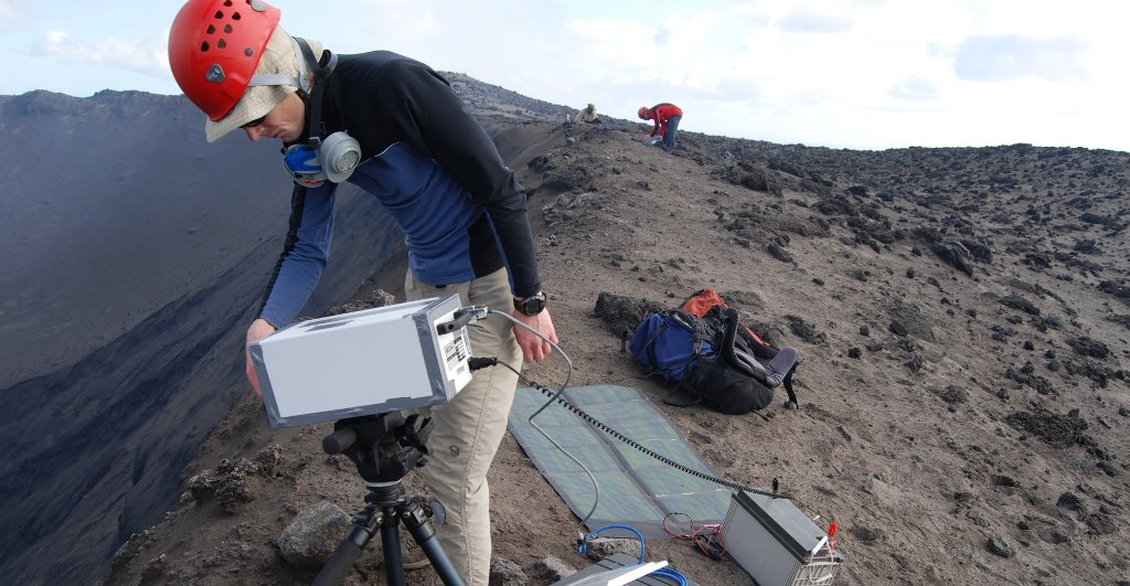
Satellites and Fieldwork
With daily observations, tracking sulfur dioxide emissions via satellite can also help with eruption forecasting. Along with measuring seismic activity and ground deformation, scientists monitoring satellite data can potentially pick up noticeable increases in gas emissions that may precede eruptions.

“It’s complementary to ground-based monitoring,” Carn says, adding that his team says both are needed. “Ground-based measurements of volcanic gases that are more difficult to measure from space, such as carbon dioxide, are crucial. But the satellite data could allow us to target new ground-based measurements at unmonitored volcanoes more effectively, leading to better estimates of volcanic carbon dioxide emissions.”
Ground-based data are more detailed, and in areas like Central America where large sulfur dioxide-emitting volcanoes are close together, they better distinguish which specific volcano gas plumes come from. However, while field measurements of sulfur dioxide emissions are increasing, they still remain too sparse to piece together a cohesive global picture.
That’s where this new inventory is handy; it reaches as far as the remote volcanoes of the Aleutian Islands and provides consistent measurements over time from the world’s biggest emitters, including Ambrym in Vanuatu and Kilauea in Hawaii.
Next Steps
“Satellites provide us with a unique ‘big picture’ view of volcanic emissions that is difficult to obtain using other techniques,” Carn says. “We can use this to look at trends in sulfur dioxide emissions on the scale of an entire volcanic arc.”

The work highlights the necessity of consistent long-term data, according to co-author Nick Krotkov, an atmospheric scientist at NASA's Goddard Space Flight Center in Greenbelt, Maryland, which produces the sulfur dioxide data from the Aura satellite. "If you want to look at trends or do other science, the longer time-series is really critical. The value of the data increases with its duration," he said.
The new volcanic emissions information pulls together opportunities to improve monitoring of natural hazards, human health risks and climate processes—one volcanic breath at a time.
Read the paper here.
For more information about past and current satellite sulfur dioxide data, visit NASA’s global sulfur dioxide monitoring web site: https://so2.gsfc.nasa.gov
To learn about atmospheric composition measurements from visit: https://aura.gsfc.nasa.gov/
Michigan Technological University is an R1 public research university founded in 1885 in Houghton, and is home to nearly 7,500 students from more than 60 countries around the world. Consistently ranked among the best universities in the country for return on investment, Michigan's flagship technological university offers more than 185 undergraduate and graduate degree programs in science, technology, engineering, mathematics, computing, forestry, business, health professions, robotics, psychology, social sciences, humanities, and the arts. The rural campus is situated just miles from Lake Superior in Michigan's Upper Peninsula, offering year-round opportunities for outdoor adventure.


Comments