MTRI is a recognized leader in the research, development, and practical application of sensor and information technology to solve critical problems in national security, protecting and evaluating critical infrastructure, bioinformatics, earth sciences, and environmental processes.
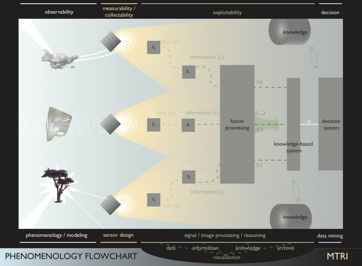
The Institute works to establish the pairing of new phenomenological (cause-effect) understandings and the development of mathematical paradigms to extract new knowledge from existing and non-traditional data sources that lets the responsible party make better decisions in the real world. It is the combination of the phenomenological model, and an understanding of the sensing mechanism that pervades the approaches being developed to more accurately and completely reflect the state of the system(s) under observation and the strength of the conclusions reached on the system's purpose and intent (future state).
Core Expertise
Remote Sensing Systems
- Radar scattering and imaging for military and civil applications
- Radar and electro optic sensing for agricultural, water quality, ecological, environmental, and transportation applications
- Research into “with-in” building imaging and exploitation
- Synthetic aperture concepts for communications
- Design of multi-frequency antenna systems
- Hyperspectral theory and applications
- Acoustic theory and sensing
AI and Machine Learning
- Deep understanding of algorithms and applied math
- Parametric and non-parametric learning
- Problem-solving and analytical skills
- Heterogeneous learning systems
- Multiple programming languages
Information Processing
- Probability and statistical analysis
- Signal/signature modeling
- Space, time, wavelength, entity
- Parametric and non-parametric hypothesis testing
- Parameter estimation
- Hidden parameter estimation (inverse problems)
Remote Sensing and GIS Systems
- Mapping and monitoring wetland ecosystems
- Fire activity and effects
- Microwave sensing at soil moisture, snow, and ice conditions
- Hydrologic Modeling
- Erosion Prediction
- Wildfire smoke modeling
GIS Based Dynamic Decision Support Systems
- Water quality
- Human health
- Environmental and ecology
- Forestry and agricultural
- Oil and gas development
- Disaster monitoring
- Transportation applications
- Rip Currents
- Environmental Health
- Invasive plants
- Wildfire smoke mapping
Robotics
- Technology and design
- Science and other applied mathematics
- Resource allocation and control
Database Management and Dissemination
- Specialized Geographic Information Systems (GIS)
- Innovative relational databases
- Application specific web/portals
- Unique/efficient Internet Map Servers (IMS)
Experiment Design and Execution of Remote Sensing Field Studies
- Flight line generation/satellite acquisition
- Remote areas
- Rigorous ground truth
- Hypothesis testing
- Multi-fusion data sets
Biomedical Sensing
- Tissue segmentation
- Sleep analysis
- Object morphology
- Active and passive imaging technologies
Workshop, Focus Groups, and Technical Conferences
- Trained facilitators
- Technical focus groups
- International remote sensing conferences
Collection of Field Data
- Aquatic remote sensing
- UAS and aerial sensing
- Leaf Area Index (LAI)
- Water quality sampling
- Agricultural crop identification
- Burn severity assessments
- Evaluation of bridge decks
- Invasive species monitoring
- Wetland characterization
- Radar and EO collections
- Mountainous terrain
- Arctic terrain/glaciers
- Military Operations in Urban Terrain (MOUT) sites
- Desert terrain
- Swamp/wetlands/tropical terrain
- Road conditions
- In situ, tower and UAS mounted sensors
- Surface and underwater sensing