

Thanks to a partnership between Michigan Tech and the U.S. Geological Survey (USGS), the flow monitoring gauge on the Pilgrim River will be replaced in spring 2020.
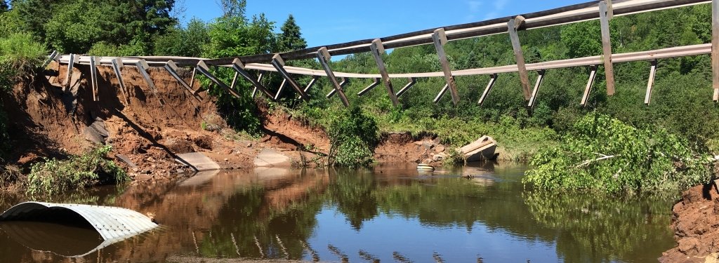
Houghton County continues to recover from the June 17, 2018 flood, when a 1,000-year rainfall event caused by a series of thunderstorms dropped as much as 6.25 inches of rain that led to severe flooding of area streams and rivers. Roads and bridges have been repaired, families are rebuilding their homes, wildlife like beaver and fish are finding new places to live, and our communities are considering how to be resilient in a future with bigger and potentially more frequent summer storms.
Stream Gauges on the Keweenaw Peninsula
Thomas Weaver, supervisory hydrologist and section chief with USGS will give a public presentation March 11, 2020 at 7 p.m. about data collected from stream gauges, why stream data is important for infrastructure design and repair as well as fishery and ecology management, and how we can support the USGS in continuing the collection of stream data in our watersheds. In room 202 at the Great Lakes Research Center, Weaver’s presentation follows the annual meeting of the Copper Country Chapter of Trout Unlimited.
When the bridge and culvert on the Pilgrim River at Paradise Road washed out during the historic flood, the floodwater took with it the monitoring equipment the USGS had installed there in 2014.
Data collected at this site was invaluable for predicting regional flood susceptibility and for ongoing research and teaching at Michigan Technological University. After the flood, the USGS completed a high-flow reconstruction that showed that the discharge on the Pilgrim River during the flood likely reached 7,370 cubic feet per second. This high-flow reconstruction makes the flow monitoring record at the Pilgrim River even more valuable — recordings of high-flow events lead to more accurate predictions of future floods — yet funding for the gauge was scheduled to end anyway in October 2018.
With no bridge and without a funding partnership to support the gauge moving forward, the USGS could not justify reinstalling the gauge.
This spring, that will change. Thanks to a cooperative agreement between Michigan Tech and the USGS, and with the support of Portage Township and Copper Country Chapter of Trout Unlimited, the river gauge at Paradise Road will be reinstalled. Michigan Tech will support operation of the gauge for the next five years with funding from the Natural Resources, Water and Energy Tech Forward initiative. The funding will give the local community time to build a broader coalition of stakeholders and interested parties, with the goal of insuring operation of the gauge permanently into the future. It will also form the cornerstone of efforts to establish a wider monitoring network on the Pilgrim River.
About the Researcher

Amy Marcarelli
ammarcar@mtu.edu
906-487-2867
Research Interests
- Limnology
- Ecosystem Ecology of Streams and Rivers
- Biogeochemistry
The Pilgrim River gauge is part of the nationwide streamflow monitoring program operated by the USGS in partnership with a variety of organizations. Through this arrangement, Michigan Tech is joining a local community of groups dedicated to supporting this important monitoring network. For example, gauges on the Falls and Silver rivers in Baraga County are operated in cooperation with Keweenaw Bay Indian Community, Baraga County Chamber of Commerce and Keweenaw Bay Ojibwa Community College. The gauge on the Trap Rock River in Houghton County is operated in cooperation with the Michigan Department of Environment, Great Lakes and Energy.
Replacing the Pilgrim River gauge is vital for our local community, yet it is just a drop in the bucket when it comes to the challenge of understanding river flow at the national scale. In an interview with Michigan Tech staff in March 2019, Don Cline, associate director for Water Resources for the USGS, said, “From a sampling perspective, in the U.S. we don’t really measure our water… That needs to change as we face ever more challenging water issues across different parts of the country, whether it’s too much or too little or poor quality.”
Here at Michigan Tech, we are prepared to help address this challenge, one gauge at a time.
Michigan Technological University is an R1 public research university founded in 1885 in Houghton, and is home to nearly 7,500 students from more than 60 countries around the world. Consistently ranked among the best universities in the country for return on investment, Michigan's flagship technological university offers more than 185 undergraduate and graduate degree programs in science, technology, engineering, mathematics, computing, forestry, business, health professions, robotics, psychology, social sciences, humanities, and the arts. The rural campus is situated just miles from Lake Superior in Michigan's Upper Peninsula, offering year-round opportunities for outdoor adventure.


Comments