
The Keweenaw Peninsula shoreline tells a billion-year-old story forged in fire, sculpted by ice. Geoheritage tours teach visitors and residents how to read the variegated cliffs, long-tailed tombolos and shifting sands. To see where volcanoes, glaciers and humans irrevocably altered topography. Bill Rose, a Michigan Tech professor emeritus of geology who developed and leads the tours, calls it “geopoetry.”
Visiting tour expert Jo Kalliokoski, head of Michigan Tech’s Geological and Mining Engineering and Sciences Department from 1968-88, is more prosaic. He rolls his eyes and makes a manure-shoveling motion. And holds up an irregularly polka-dotted piece of Jacobsville sandstone for the 15 geotourists gathered on the beach.
“You may have wondered what creates these markings.” The 1995 College of Engineering Academy inductee waits a beat like a comedian delivering the punchline:
“We’re not sure.”
Geology with a Side of Humor
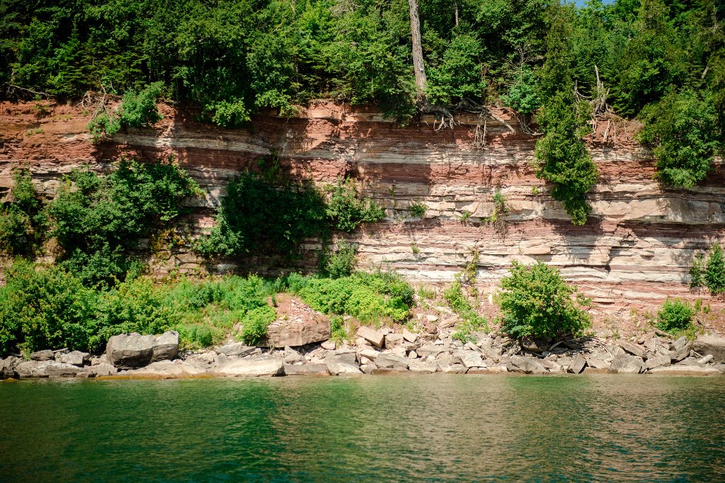
There is an explanation for why the rocks are red: they're colored by hematite, occurring as oxidized iron. And while the artful precision of stripes, swirls, dashes and circles isn't entirely explicable, the white areas, known as reduction spots, are where material was present that inhibited oxidation, or where a secondary reaction leached away the color.

Geoheritage tours are one of several components in an initiative designed to get folks excited about the peninsula's world-class natural wonders. For four years, a week-long series of day-long tours has been welcoming visitors to explore Keweenaw's glacial and volcanic past, as well as its mining history, by land and water. Once covered with ice two miles thick and the site of Earth's largest ancient lava outpourings, the peninsula's split personality is readily apparent to either side of the Keweenaw Fault. An upheaval that exposed the copper so crucial to European settlement of the region birthed distinct and dramatic landscape features. Northwest of the rift lie great lava reefs, juxtaposed against glacial deposits of boulders and moraines. To the southeast, an expanse of layered rocks with magnificent exposures of rich red and rust-and-cream variegated sandstone. Jacobsville sandstone, named for the community at the heart of its locale, is the focus of the final tour of the week.

Why does the Keweenaw have so much sandstone?
The vast Jacobsville sandstone unit is a remainder of an old continent that rifted apart. The Huron Mountains were once 10,000 feet tall; the Mesabi range of Minnesota and the Penokees of Wisconsin were also much larger than they are today. The youngest sedimentary rocks are about one billion years old. The range is far-reaching, from Munising (home to the Pictured Rocks), extending to the western basin of Lake Superior. The geotour covers a short segment of a very large system.
On the western shore of Keweenaw, the brown, mud-filled Freda sandstone may be even older. “You can’t date a sediment very easily,” says Kalliokoski. Radiometric dating is a grain-by-grain process.
"If you have a hole in geology it gets filled. Red sandstone is just the top layer."
Next, the group boards Michigan Tech's research vessel Agassiz to view features that can't be seen from shore.

White Beach, Black Beach
Sandstone is the focal point, but stamp sand is the photobomb. There's no way to ignore its ever-encroaching presence extending from Gay to Traverse Bay. Carried by Lake Superior’s strong counter-clockwise current that rebounds and builds off the peninsula, the industrial black sands—thousands of cubic feet deposited during copper mining milling operations—steadily migrate south along the shore and east out into the lake where depths rise abruptly from eight meters to three meters while the boat is still far offshore. The sands directly affect the tour, because participants can't board the Agassiz at the usual spot; Schoolcraft Township boat landing at Big Traverse pier is inaccessible. Though it was dredged by the US Army Corps of Engineers last year, the stamp sands have already filled in the channel leading to the dock. There isn’t enough depth for the Agassiz’s 4.5-foot draft. Instead, the group boards at Dockside Resort, at the Kauppi family fishing pier directly on the lake.
Geoheritage tours are interactive. Folks with expertise in a particular area are encouraged to share it. Social, historical, economic and even legal factors are open for discussion.
At Rose’s request retired local attorney Jim Tercha helps lead the dialogue on the encroaching black sands deposited in front of private homes. Who do the sands belong to? Who is responsible for them? What would remediation, reclamation, or litigation look like?
As Tercha notes, from the vegetation line to the water, the public has a right to access. Owners likely have the best claim to these moveable beaches. The mining companies and their shareholders are gone. There are no wrong answers, as Rose notes. It’s getting warm. Cold pop and water is handed around from coolers on the deck floor. Snacks circulate along with good-natured debate among the 19 aboard.
Noting that blocking the lake upsets the balance, Kalliokoski says that building in the future can be different. "Setbacks required, not so close to shore."
"Ignoring flood plains is never a good idea. Sooner or later the lake will win."
There's No Place Like Home (in Keweenaw)
For Rose, these tours are the ultimate geo-social connection.
"Earth science and geology wasn't very social, historically. I wanted to meet my neighbors. Now I know a lot of them."
Some geotourists are long-time locals. Chris Jamsen Protz of Jamsen's Fish Market and the Fishermen’s Daughter on the Copper Harbor docks was born in Gay. "I grew up in this area," she says, "and I'm just now learning more about it."
There are geologists and geophysicists aboard, along with passionate rockhounds and geology buffs.
"I am the Agate Queen."

For a few residents, the view of their own piece of Keweenaw is a highlight of the experience. Bonnie Brandt smiles broadly; she's never seen her home on the Rabbit Bay shore from this vantage.
The excursion also included a trip to Rabbit Island, where geotourists visited with the co-founders of Rabbit Island Foundation and the artists in residence.
Long-tailed Islands, Prized Red Slabs
The Keweenaw's points, including Point Isabelle and Point Louis, stand in dramatic bas-relief against a horizon of clear blue sky and azure water. The land masses are classic tombolos—long-tailed islands, or land spits attached to the mainland by a strip of sand, Rose explains. Wave energy concentrates at the points.
Heading toward Jacobsville and the south entry of the Keweenaw Waterway, guides encourage geotourists to try and determine where stone was quarried, and where huge chunks fall off naturally about every 50 years.
"Exploring the channels of deposit, we see the layers are less porous and crumbly, more consistently solid red," Rose notes.
As the Agassiz leisurely trolls the shoreline, slightly to the north of Jacobsville, homogenous sections, of a consistent color and density, prized by customers of yesteryear are abundant. This was the center of activity for the quarries that operated here from the 1880s to the early 1900s. Old docks, submerged slabs and other remnants are visible. In its short-lived heyday, Jacobsville Sandstone was popular from New York to St. Louis, and all over the Copper Country. After the Great Chicago Fire of 1871, stone buildings seemed like a better idea, Rose says.
"People liked the color. They became fashionable."
But fashion is fickle. Marble wowed the crowd at the Chicago World's Fair, and just like that, sandstone was out. The town, with a population of more than 1,000 in its heyday, went down to almost nothing, Rose says, and many Jacobsville homes were floated up to Hancock. The community that remains includes long-time residents who remember sandstone quarrying's glory days and share their stories with geotourists.
Creating a Global Geopark in the Keweenaw
Every community in the state can stake a Pure Michigan claim. But the largest lava flows in the world and a failed ocean called Lake Superior? You have to come to Keweenaw for superlatives like that.
"Our geoheritage defines us; we connect to geology in a multitude of ways" says Erika Vye, Michigan Tech PhD geology graduate and a leader in the Keweenaw geoheritage movement. As an offhand example, she points to the pasty, a traditional hand-warming meat-and-vegetable pie that's here because of our rich copper mining history. And copper mining was so successful because of a miraculous coalescence of globally significant geologic processes that created the Keweenaw. Vye says the Keweenaw could be the first Global Geopark in the United States.
Geoheritage tours are an example of the holistic approach a geopark engenders, says Vye. For example, the pasty lunch was purchased from a local restaurant, and a local resort owner provided dock access for the Agassiz to take on passengers. Partnership possibilities with local communities and schools abound.
Michigan Technological University is an R1 public research university founded in 1885 in Houghton, and is home to nearly 7,500 students from more than 60 countries around the world. Consistently ranked among the best universities in the country for return on investment, Michigan's flagship technological university offers more than 185 undergraduate and graduate degree programs in science and technology, engineering, computing, forestry, business, health professions, humanities, mathematics, social sciences, and the arts. The rural campus is situated just miles from Lake Superior in Michigan's Upper Peninsula, offering year-round opportunities for outdoor adventure.

Comments