Stabilizing Geotechnical Assets: New Research Aims to Identify Potential Highway, Railroad Problems

While we’re able to enjoy timeless scenery as we travel in the United States, it’s important to realize that the soils and rocks forming the base of these transportation systems may not forever be stable.
In a new project led by Michigan Technological University, Thomas Oommen, assistant professor of geological and mining engineering and sciences, heads a team that is using advanced technology to develop a comprehensive management system to monitor our nation’s geotechnical assets—the ground that forms the base for the concrete, asphalt or steel that makes up our transportation system. Co-investigators include Colin Brooks, senior research scientist at the Michigan Tech Research Institute (MTRI); Pasi Lautala, assistant professor of civil and environmental engineering; Stan Vitton, associate professor of civil and environmental engineering; and Keith Cunningham, a research professor from the University of Alaska–Fairbanks.
The one common theme for US transportation infrastructure is that it is supported by the ground, constructed over it, through it or next to it. Scientists call these natural bases geotechnical assets. The problem, however, is that we do not have a comprehensive program in the US to monitor the geotechnical assets of our transportation corridors. That is, until now.
“There are so many geotechnical assets in road, rail and pipeline transportation systems,” Oommen says. “And the first question people ask is why there is no comprehensive monitoring of these assets. It is because the scale of the task is huge!”
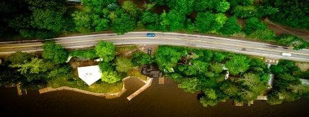
The team has worked in a variety of locations, from Detroit’s highways to western railways to Alaskan pipelines. To date, studies have taken place in Michigan, Nevada and Alaska.
With changing weather, increased traffic and aging infrastructure, more failures are bound to occur. Oommen’s team has been monitoring steep slopes along railroad grades, where rockfalls are an immense hazard. These routes cover thousands of miles, and the cost of monitoring these assets means that issues are mainly ignored unless they are serious.
With a new suite of technological tools, however, monitoring can be much more targeted, resulting in the prevention of problems before they occur and at a significantly lower cost.
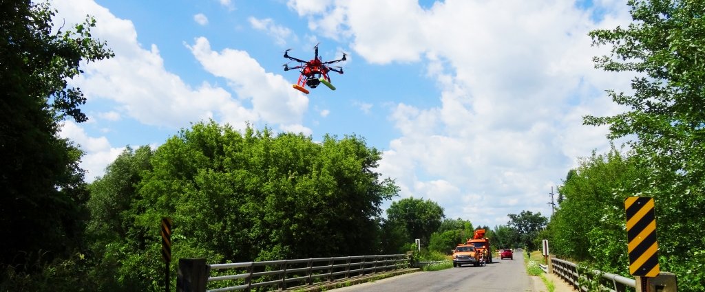
“We can use a variety of remote-sensing techniques, from Optical Photogrammetry (OP) to LiDAR (a portmanteau of light and radar using lasers) to Interferometric Synthetic Aperture Radar (InSAR),” he says. “Our project is determining which of these techniques is best and most economically sustainable for monitoring geotechnical assets for transportation.”
Economic sustainability is a major factor; corporations looking at the bottom line and governments facing budget scrutiny cannot afford massive capital outlays. Working alongside Union Pacific, Alyeska Pipeline Company, and the Michigan and Alaska Departments of Transportation, the team is mindful of finding affordable solutions to this massive challenge.
“These techniques, some of them can work well with just a typical Digital Single Lens Reflex (DSLR) camera,” Oommen says. “Comparing that to the expense and time involved with LiDAR and OP makes a great deal of sense.”
Using OP, Oommen’s team has been able to detect slight movements in small-scale structures
in the lab using a standard digital camera. The structure is photographed from different
angles, and then made into a 3D model using sophisticated software. This provides
a great deal of accuracy at a relatively low cost.
“State agencies are doing asset inventories and they see the scale of the problem,”
Oommen says. “But it’s a challenge to decide what to do about it.”
A test site for adopting OP techniques has been a ten-mile-long series of retaining walls on a Detroit-area highway. The team monitored these walls through a variety of weather conditions, including winter melt and heavy rains. After one particularly strong storm, they noted a couple of inches worth of movement.
As a result, the retaining wall was able to be rebuilt before it failed.
“Our goal is to fundamentally transform geotechnical asset management to be more proactive and cost-effective,” explains Daniel Cerminaro, a graduate student who has been instrumental in fine-tuning the OP process in the lab.
On a larger scale, using satellite and overhead imagery, the team has been able to analyze movement over entire regions, identifying slopes that are of concern and examining and remediating these trouble spots.
“We’re still refining the technique,” Oommen says. “But the technology and the ability are available and we’re proving that.”
In the future, it’s highly likely that cameras mounted on unpiloted aerial vehicles (UAVs), cars and trains will monitor entire networks automatically, sending imagery back for analysis of potential instability. Recently, MTRI has used a high-speed camera that could potentially allow, for example, a car to travel at the speed limit and still get accurate imagery for use with the OP method.
This research is supported by the US Department of Transportation Office of the Assistant Secretary for Research and Technology (USDOT/OST-R). The two-year project has a budget of around $1.5 million.
Disclaimer: The views, opinions, findings, and conclusions reflected in this article are the responsibility of the authors only and do not represent the official policy or position of the USDOT/OST-R, or any state or other entity.
Michigan Technological University is an R1 public research university founded in 1885 in Houghton, and is home to nearly 7,500 students from more than 60 countries around the world. Consistently ranked among the best universities in the country for return on investment, Michigan's flagship technological university offers more than 185 undergraduate and graduate degree programs in science and technology, engineering, computing, forestry, business, health professions, humanities, mathematics, social sciences, and the arts. The rural campus is situated just miles from Lake Superior in Michigan's Upper Peninsula, offering year-round opportunities for outdoor adventure.

Comments