Answer: it's complicated. A transdisciplinary team led by Michigan Tech tracks pollutants while looking for solutions to reduce exposure for a local Indigenous community.
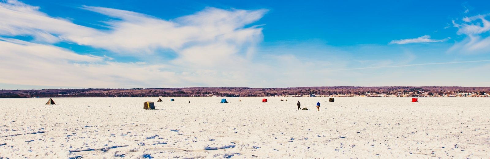
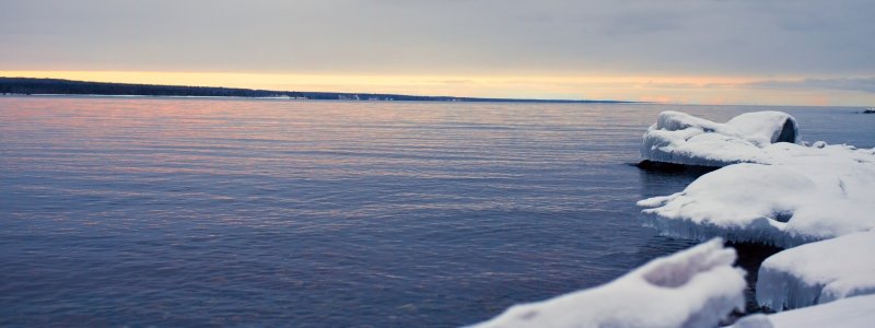
Cold—it’s the first feature anyone notices about Lake Superior. Then there are the rocks; reds and blacks spewed by ancient volcanism and shaped by waves, granites shrugged off the shoulders of the Canadian shield. On the Keweenaw Peninsula, some of those rocks glint with copper, and hemlocks grow on the slopes up and away from the beach. Tree-covered ridges rise inland while the water stretches out—a deep, dark blue curving beyond the horizon. Sunsets, the northern lights, storm clouds seem to fill the whole sky.
In a word, beautiful. Although not necessarily pristine.
For as cold, clear, and clean as Lake Superior appears, it is not as isolated as some of its rural communities feel. All of the Great Lakes are connected—to each other and the rest of the world. This is particularly true when it comes to atmosphere-surface exchangeable pollutants (ASEPs).
"ASEP: atmosphere-surface exchangeable pollutant"
Mercury; polychlorinated biphenyl; polycyclic aromatic hydrocarbons; persistent organic pollutants. ASEP molecules are invisible, tasteless world-hoppers that can travel great distances to eventually migrate to Lake Superior, where they move through the air, land, small lakes, big water, sediments, insect nymphs, crawdads, birds, fish, and humans. Researchers can describe ASEP movement and impacts through policy, socioeconomic pressures, ecosystem services, stressors like climate change and land use, and biogeochemical cycling.
For the local Indigenous community, the complexity comes down to one question: When can we eat the fish?
The problem in the Keweenaw is two-fold: With a global background that continuously supplies local fluxes of the mobile contaminants, efforts to mitigate ASEPs are minimally effective on a regional scale; at the same time, the peninsula’s ecosystems and people remain some of the most sensitive and vulnerable in the world.
Judith Perlinger, professor of environmental engineering, is the lead researcher of a project funded by the National Science Foundation (NSF) that set out to investigate the migration of ASEPs around the world and its local impact on people, especially in fish-reliant populations like the Keweenaw Bay Indian Community (KBIC). Their research focused on mercury is part of a special issue of Environmental Science: Processes & Impacts, a journal published by the Royal Society of Chemistry. The work reflects how global issues have local impacts.
“Defining ‘safe’ fish consumption for the most vulnerable people helps protects us all,” Perlinger says, adding that her work is embedded in a large, transdisciplinary effort— six institutions, 36 researchers, and 11 partnering organizations—all seeking to better understand ASEPs. “Although they have uses, their point of use and the damage they cause are separated by time and space, which is why studying ASEPs here is important.”
Think globally, sample locally
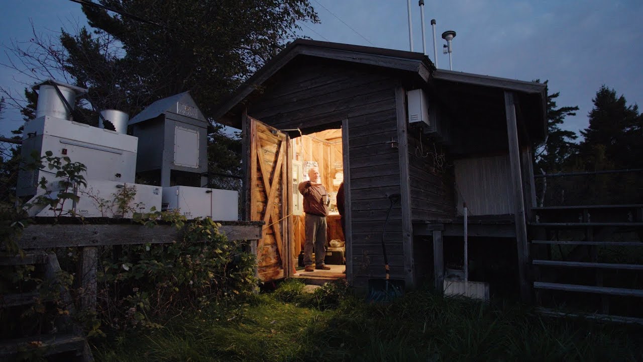
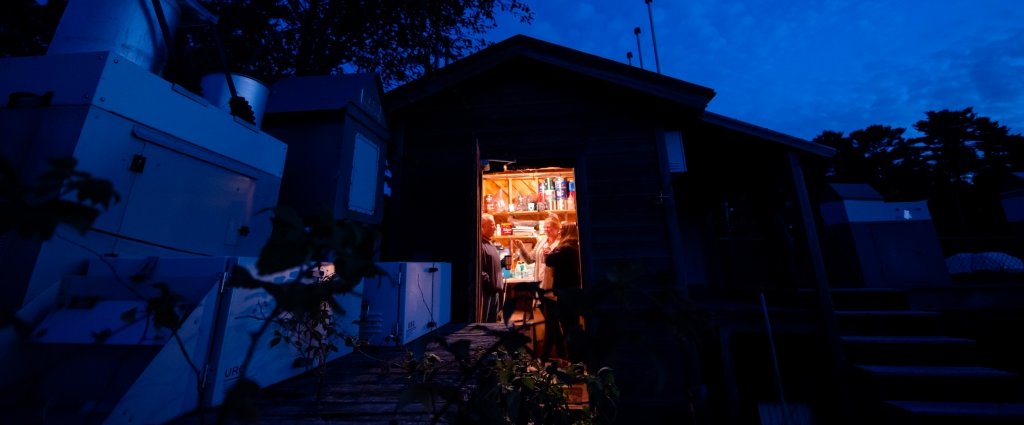
The sunrise this morning refuses to let go of its magenta edges. As dusk shifts blue, the waves coming into Eagle Harbor kick up sediment, beating a brown rhythm against the shore past the Michigan Department of Natural Resource’s Eagle Harbor State Dock. About a hundred yards in, chain link fence marks off a yellowed, weedy square encircled by a deck topped with tall, silver boxes that look like space-age trash cans. Stepping onto a deck stair, no one seemed to bother with varnishing the planks, and although only installed three years ago, the pine has grayed.
“There’s good reason for that,” says Don Keith, a local Eagle Harbor retiree with a southern drawl from his Florida roots, pointing at the deck and then four feet down to a tangle of spotted knapweed and tansy. “Everyone asks why I don’t keep down the weeds, but I can’t.”
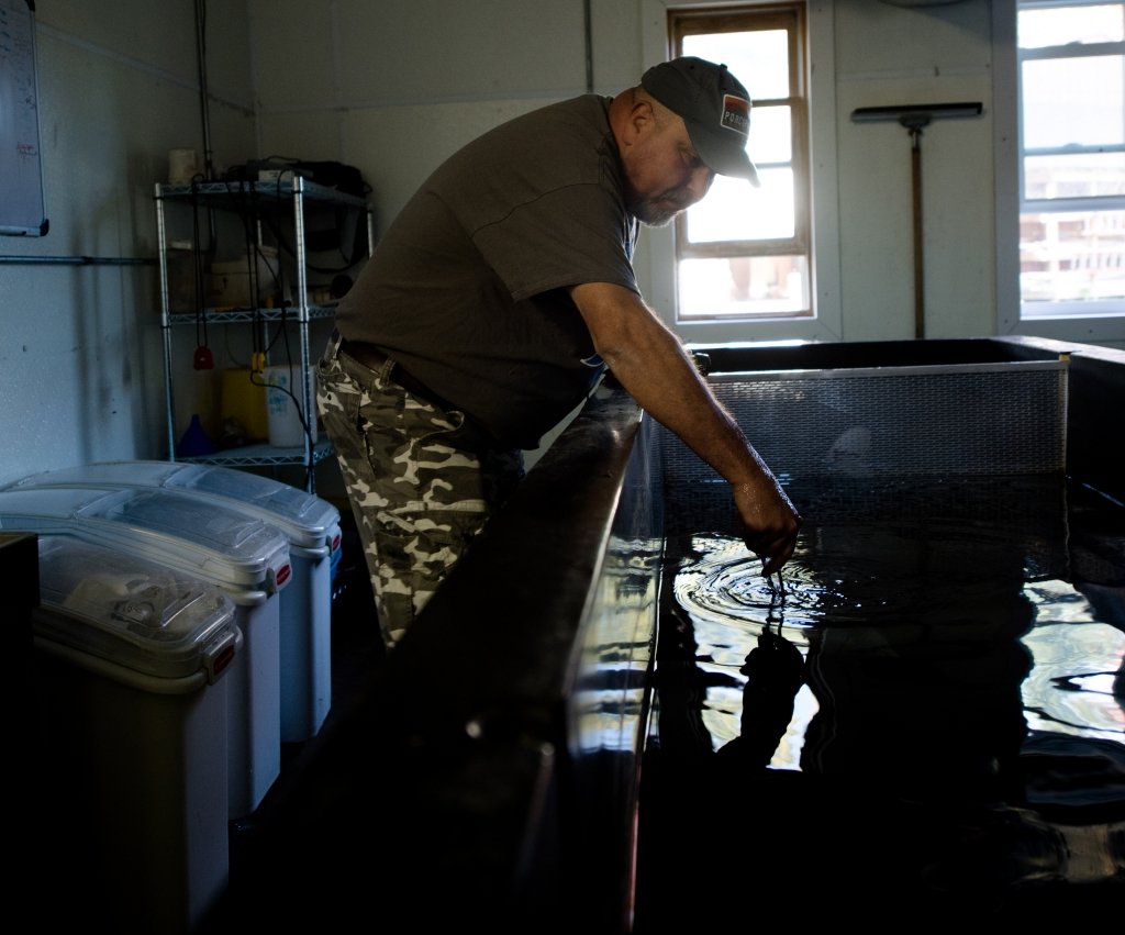
That’s because this is an atmospheric sampling station. Gas from a weed-whip, or deck sealant, or engine fumes from boats leaving the public dock, gum up the filters resting inside the silver boxes. Keith reaches to the side of one where a metal arm holds up a small sensor; the heat of his hand triggers the machine inside and it opens like the gullwing doors on a fancy sports car. Inside, a small glass and metal tube rest, passively gathering air and locking it away. Keith moves from silver rectangle to silver rectangle as the sky’s magenta finally fades, explaining the nuances of each. This one is a high-volume air sampler, the latch on this filter freezes every storm, mercury coming in on the jet stream from coal-burning in China gets captured in this one. He would know each piece of equipment well; Keith has been coming out to the station once a week for 25 years to gather the samples, record meteorological data, and ship them off for processing.
The data gleaned from Eagle Harbor, and nearly 200 other sites around the country, as well as many others around the world, help inform global atmospheric models, including the one used by Perlinger’s team. They use GEOS-Chem, a global three-dimensional Eulerian chemical transport model that has been widely used to better understand tropospheric chemistry and composition. For ASEPs, GEOS-Chem helps sift through the sources, migration, exchange rates, and resting places of the pollutants. It is coupled with a mass balance modeling to understand the aquatic dynamics of the system.
The question becomes how do people and smaller-scale ASEP movements fit into the bigger picture. For even though the Keweenaw has some of the cleanest water and air in the world, the region still accumulates the world’s pollution.
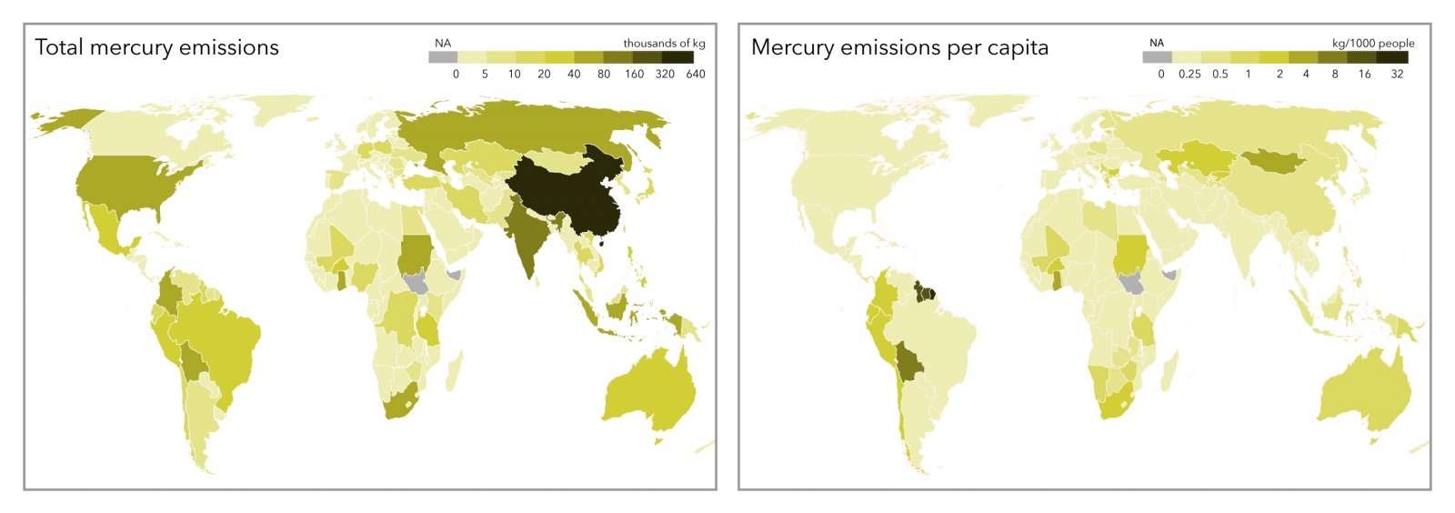
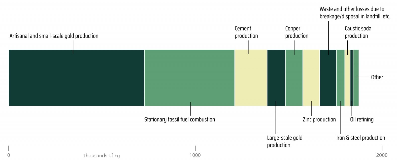
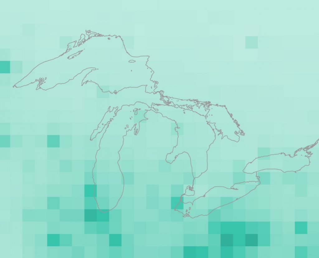
Mercury sources 2010, by country
Along Keweenaw Bay
The winds are so strong that car doors whip close, which is common along the shores of Keweenaw Bay in the Ojibwa Recreation Area. Gravel paths wander through swales built up around a pond next to a gray beach. Bright heads of black-eyed susans and the rattling stalks of coneflowers sway below petite, seven- year-old pincherry trees. Sometimes the gusts bring an extra bite. Flakes of stamp sand—the grayish-black leavings of past mining operations on the water’s edge, concentrated with heavy metals— are so sharp that they slice through the plants like tiny razors. The KBIC Natural Resource Department (NRD) staff now do clump planting, and the first line of defense against wind, waves, and sand are stands full of “warrior species” that protect other plants. Throughout the site, each stand features a small plaque with the plant’s Ojibwa name, Latin name, and common name.
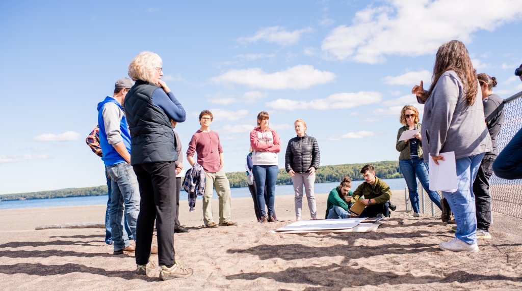
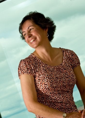
“The restoration not only protects the shoreline ecosystem, but also buffers the wetlands where wild rice beds, cranberries, and many medicinal plants, and wildlife live,” says Evelyn Ravindran, one of the KBIC-NRD staff who often leads tours and volunteer plantings. She explains, along with Lori Ann Sherman, director of the KBIC-NRD, that the Ojibwa Recreation Area shows why the community needs both traditional knowledge and scientific knowledge.
“Traditional knowledge is gained from our elders and is learned by doing and experience. There is cross-over with scientific knowledge and there needs to be,” Sherman explains. “As Anishinaabe people, we are stewards of this land.”
Anishinaabe means “Original People” and stewardship is part of the original instructions imparted to all living things in the Anishinaabe creation story. Each nation—human, fish, bird, plant—all take care of each other.
“Traditional knowledge fosters our beliefs and values; it nurtures our connection to this place, with teachings of respect, reciprocity, and enduring sustainability. These beliefs and values guide us in our questions and where we choose to put our efforts,” Ravindran says. “Scientific knowledge provides more of a worldview and helps us to better understand how outside influences, such as legacy mining, affect our landscape and way of life.”
"Talking about the fish is a ploy. What we're really talking about is the health of the land and the water—and they matter."
From an Anishinaabe perspective, the natural environment is an extension of the community’s relatives; the tribe’s responsibility then is to be accountable for the human nation’s impact on the health and well-being of other nations. The ASEP project similarly acknowledges that humans are not separate from nature; in technical terms, they say ASEP deposition is part of a dynamic, coupled human-natural system. In order to describe all the elements within that system—including the Indigenous community’s perspective and their desired fish consumption rates at target ASEP pollutant levels—they sought to come up with a meaningful question that resonated with both the research goals and KBIC’s needs. That’s how the question, “When can we eat the fish?” came in.
Quickly injured, slow to heal
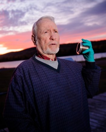
“It will likely take multiple generations to reach levels considered safe by the KBIC in Lake Superior fish,” says Noel Urban, professor of environmental engineering and an ASEP project researcher who focuses on the biogeochemistry of the pollutants. “How much can a landscape absorb? That varies geographically. The landscape in this environment is particularly sensitive to mercury deposition.”
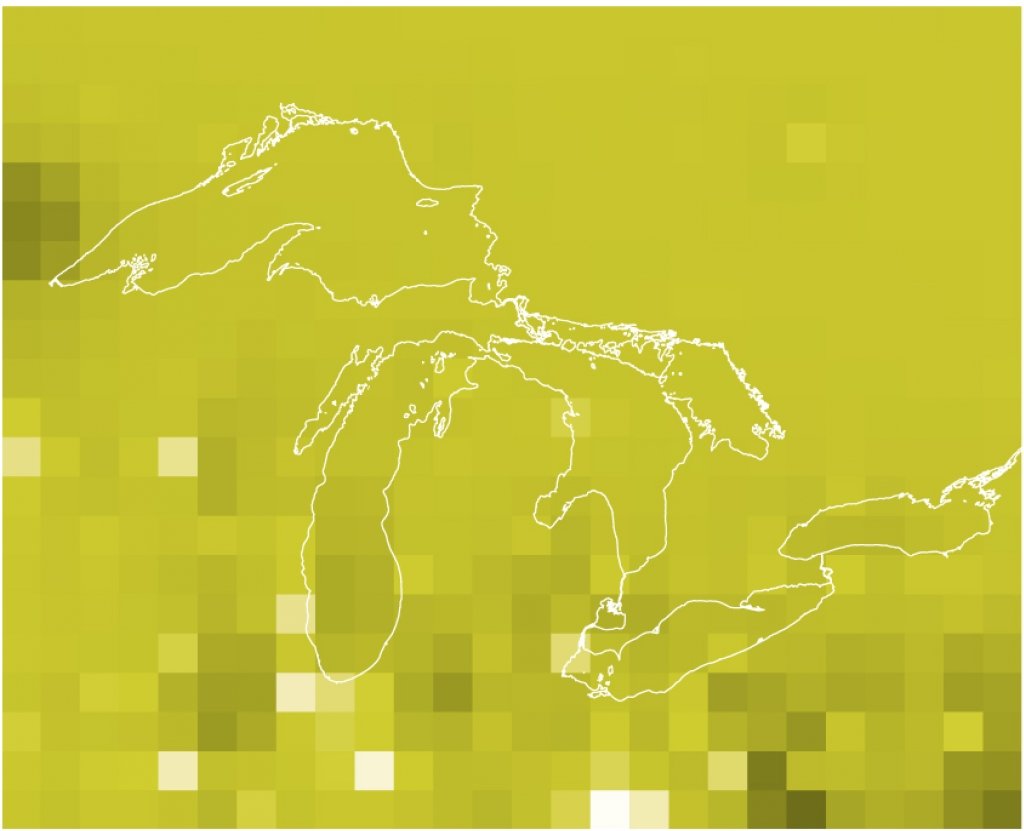
Mercury sources 2010, by type
That’s because even though mercury deposition is low, the Upper Peninsula landscape has a long memory and recovery time. Also, based on the analyses by Urban’s team of more than 100 Upper Peninsula water bodies, mercury behaves differently in small inland lakes compared to larger bodies of water; Lake Superior is practically its own category. Other contaminants like polychlorinated biphenyl (PCB) compounds also vary.
Chronic exposure is the problem. Occasionally eating smoked lake trout at a tourist stop is not the same as eating trout, walleye, and whitefish multiple times a week because it’s both an accessible and cultural food staple.
Urban’s goal is to extrapolate fish mercury concentration data from lakes and estimate mercury in fish from similar water bodies based on pH, phosphorus, and Secchi disk depth readings. He works with the Great Lakes Indian Fish and Wildlife Commission (GLIFWC), one of the ASEP research partner organizations. The team focused on three different policy scenarios that would impact Great Lakes mercury deposition: an ideal, aspirational target; a policy-in-action target; and a minimal policy target. Less action, more pollution. However, none of the scenarios will make fish safe to eat by the KBIC’s standards by 2050.
Predicted mercury deposition in the Great Lakes in 2050
Output from the GEOS-Chem model, which incorporates changes in mercury emissions from human activities, show that mercury regulations currently in place and under consideration will only decrease mercury deposition in the Great Lakes region by 20 percent by 2050, which is not enough for the KBIC to safely consume fish at desired levels.

This scenario assumes mercury emissions around the world stop tomorrow.
This scenario is based on emissions limits currently in place and under consideration.
This scenario assumes that mercury emissions are minimally regulated.
Credit: Kaye LaFond
From academia to agencies to citizen scientists, what all of the ASEP researchers are quick to point out is that mercury, PCBs, and other atmosphere-water exchangeable pollutants are not new. The issue is that they are not going away any time soon, and decades-old conversations about temporary stop-gaps have not progressed. Plus, local and regional efforts to reduce ASEP pollution simply can’t compete with global background levels. To better articulate an answer for the KBIC, the research team turned to one of the earliest policy measures—fish consumption advisories.
Rethinking fish consumption advisories
All 50 states, many Native American tribes, and federal agencies have established more than 4,000 fish consumption advisories in the United States. However, quantity is not quality, and the policies were never meant to be long term. Which is why social scientist Valoree Gagnon and historian Hugh Gorman do not advocate for getting rid of fish consumption advisories, but instead, seek a future in which fish consumption advisories will no longer be necessary. To achieve such a future, science and policy require a shared focus on eliminating sources of contamination. They want to remind others that the advisories were not intended to be permanent.
“Advisories have been shown to have a minimal impact,” says Gagnon, a research assistant professor of social science, “especially when they impede tribal treaties and reserved fishing rights.”
Gagnon and Gorman, who is the chair of the Department of Social Sciences, are ASEP project researchers and co-authors on a policy brief titled “Eliminating the Need for Fish Consumption Advisories in the Great Lakes Region” (read it at mtu.edu/asep-policy). Emma Norman from Northwest Indian College is also a co-author.
Their take-home message:
"In the Great Lakes region, health officials first issued fish consumption advisories in the early 1970s. At the time, these advisories were considered temporary, necessary to protect the health of the fish-consuming public until sources of contamination in the Great Lakes basin could be eliminated. However, even after most local sources of contaminants were eliminated, the problem remained."
This is the crux of Keweenaw ASEP mitigation. The policy work spans geographical scales from local to regional to national to international. To answer the KBIC’s localized question—when can we eat the fish—requires global action like worldwide conventions to staunch the sources and remediate pollution.
“Neither the Minimata Convention nor the Stockholm Convention state that we want to get past fish consumption advisories,” Gorman says, explaining that the idea has become implicit in ASEP-related policy. “It’s hard to pursue a goal when it’s not fully articulated.”
Likewise, ASEP research itself must be fully articulated; science works through collaboration, sharing ideas, and new knowledge. The transdisciplinary team working on the ASEP project deepens the understanding of the pollutants’ cycling and the accuracy of modeling, evaluates multi-scale policy, and offers insight into the best practices for engaging local Indigenous communities in global research.
This information is not limited to scientific literature either—joining with the National Park Service, K-12 classrooms, and online teaching platforms, ASEP educational materials take the science-for-scientists template and shapes a different path to bring the research out of the laboratory. Doing so is yet another reflection of how Lake Superior and the Keweenaw are not isolated from the rest of the world. Indeed, the connections made here span the globe.
Michigan Technological University is a public research university founded in 1885 in Houghton, Michigan, and is home to more than 7,000 students from 55 countries around the world. Consistently ranked among the best universities in the country for return on investment, Michigan’s flagship technological university offers more than 120 undergraduate and graduate degree programs in science and technology, engineering, computing, forestry, business and economics, health professions, humanities, mathematics, social sciences, and the arts. The rural campus is situated just miles from Lake Superior in Michigan's Upper Peninsula, offering year-round opportunities for outdoor adventure.