It is perhaps fate that Rüdiger Escobar-Wolf would become a volcanologist.
He grew up in Quetzaltenango, Guatemala, a small city surrounded by volcanoes. From a young age, Volcán Santiaguito captivated him.
“I was aware of the eruptions, and we would get ash from the volcano when I was a kid,” Escobar-Wolf ‘07 ‘13, research assistant professor in the Department of Geological and Mining Engineering and Sciences, says. “Two older brothers would hike on the volcano long before I was allowed to. It always lived in my imagination as a mysterious and a very interesting place.”
When Escobar-Wolf was 12 years old, a group of family friends hiking on the volcano were killed in an eruption. It made such an impression on him, Escobar-Wolf knew he had to study volcanoes one day. But Guatemala, though a nation with many volcanoes, does not have a robust path toward studying volcanology, so Escobar-Wolf settled for civil engineering. Working as a contractor on a seismic risk project brought Escobar-Wolf into contact with another group of people—Michigan Tech researchers—working with Coordinadora Nacional para la Reducción de Desastres or CONRED, Guatemala’s disaster response agency.
William Rose, professor emeritus, began working in Guatemala on volcanoes research in the 1960s. He says that until recently, almost all of the people he met on Guatemalan volcanoes were civil engineers.
“Rüdiger was a civil engineer. Civil engineers like bridges and bricks and buildings. They don’t usually like rocks, the natural world, field work, and climbing volcanoes,” Rose says. “But Rudiger did. His mom built such a strong feeling inside him for climbing that he was a civil engineer that just loved the mountains.”
Rose convinced Escobar-Wolf to earn his master’s and PhD in geology at Michigan Tech, which Rose says is one of the best volcanology programs in the world.
“A lot of volcanology programs are laboratory oriented,” Rose says. “They have labs where they do fluid dynamics, material science, and chemistry. They measure many things including hafnium isotopes.”
"We go to the field. The volcano is our experiment."
Michigan Tech’s volcanology program participates in INVOGE, the International Geological Masters in Volcanology and Geotechniques, giving students opportunities to study in the US, Italy, and France. Tech’s program is broad, including faculty who focus on seismology and geophysics, rock composition, gases, and landslides, with a healthy dose of engineering principles.
“We can tackle problems that are unusual because we have diverse specialties and connections all over the world,” Rose says. Federica Lanza ’12 ’16 participated in the INVOGE program as a master’s degree student, and then decided to earn her doctorate at Michigan Tech. With fellow student Kyle Brill ‘11, she worked at Fuego under the direction of Greg Waite, associate professor of geological and mining engineering and sciences.
“Fuego’s persistent activity makes it an excellent natural laboratory to study vulcanological processes in open vent systems,” she says. “The proximity to numerous villages and to the populous Guatemala City puts Fuego in a high volcanic risk category, and therefore the scientific community has a high interest in studying the volcano in order to improve their knowledge on how and when the volcano could erupt.”
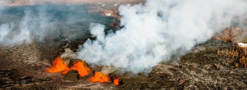
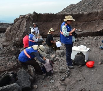
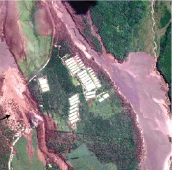
The researchers shown in this image provide evidence of the sheer size of the pyroclastic flow, which in places was as wide as a kilometer.
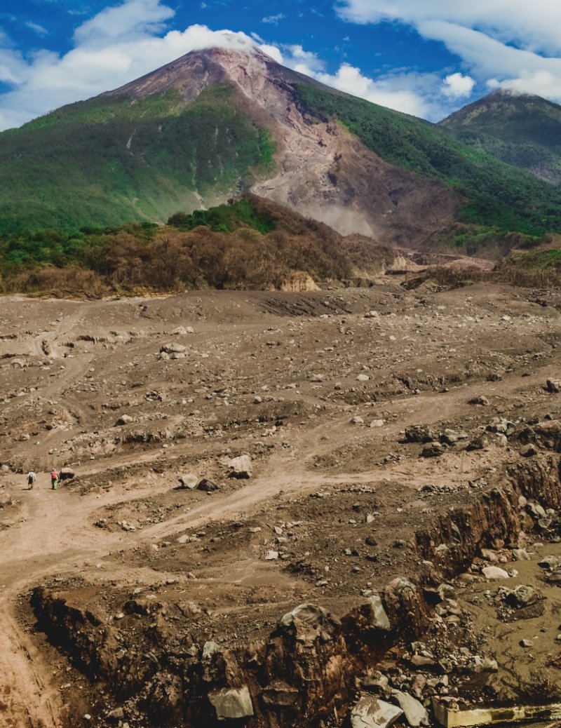
Volcán de Fuego is 12,346 feet (3,763 meters) above sea level. When the volcano erupted June 3, the pyroclastic flow carved a new path down the mountain after overwhelming the barrancas—deep channels cut into the sides of the mountain by runoff. This image, taken during a site visit in August, shows how the brute force of the pyroclastic flow reshaped the face of the mountain.
The trees and other vegetation at the edges of the pyroclastic flow were killed by heat and ash. Yet because of Guatemala's moisture, Escobar-Wolf noted that in areas the land was already beginning to green at the edges of the pyroclastic flows. When Fuego erupted in the 1970s, many signs of the eruption were erased by thick foliage within a decade.
As Guatemala enters its rainy season, areas around the volcano are threatened by lahars—debris from the eruption mobilized once again that flows down the mountainside and into the barrancas. Since the June 3 eruption, INSIVUMEH and the USGS have been working together to install new equipment and software to help mitigate the hazard from lahars by allowing scientists to better forecast and detect such events.
Lanza says an understanding of precursory signals can lead to local warnings of explosions, giving scientists, tourists, and the local population time to evacuate. During her fieldwork on the mountain, she helped install seismometers and tiltmeters in close proximity of the summit in order to collect data on the seismicity and deformation occurring at the volcano.
The data collected by these temporary sensors strengthen the permanent seismic network deployed at the volcano and allow for the identification of earthquake patterns and a special type of seismic signal that contains low frequencies.
Lanza also worked with Ezequiel Medici, research assistant professor of mechanical engineering-engineering mechanics, to install infrasound sensors to measure shock waves produced by explosive eruptions human ears cannot hear and to study the characteristics of volcanic jets.
However, perhaps the source of the program’s success is that research isn’t focused solely on the technical aspects of volcanology, but also on the effects of volcanic eruptions on human communities.
“Our goals and research aren’t just focused on scientific things like volcanic ash, gas emissions, remote sensing, and atmospheric science, but also on social aspects. We want to have a lasting input into the future in Guatemala,” Rose says.
Chain of Fire
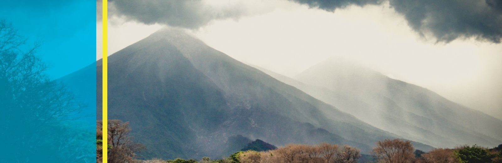
Guatemala’s volcanoes track in a line from northwest to southeast, with the Pacific Ocean to the west and Guatemala City to the east. Volcán de Fuego rises 12,346 feet (3,763 meters) from the lush forests of the Guatemalan highlands. Near the peak, the mountain is smeared with deposits of debris, which give way to greenery. The length of the stratovolcano’s haunches is marked by barrancas—deep channels cut into the sides of the mountain by runoff from Guatemala’s long rainy season. Fuego’s twin, Acatenango, sits just north.
“Guatemala is a magnificent tropical landscape, especially in the mountains. The natural vegetation is just gorgeous. There are orchids everywhere,” Rose says. “But after the eruption, the mountain is denuded, dangerous, and horrific. The volcano has changed it into a series of deep gullies you can barely traverse.”
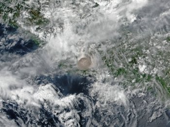
Fuego's eruptive cloud (the brownish circle in the image) rose 15 kilometers (9 miles) into the troposphere, containing gases including sulfur dioxide. Large volcanic eruptions have in the past been credited with temporarily cooling the planet's climate when the gases in eruptive clouds react in the atmosphere to create aerosol particles. When sulfur dioxide reacts with water vapor in the atmosphere it also forms acid rain.
NASA Earth Observatory image by Joshua Stevens
Like many active volcanoes, Fuego has erupted multiple times in the past few decades. Escobar-Wolf surmises these small, frequent eruptions—as often as every month—may have led to a sense of complacency in the communities around the volcano and in the nation’s emergency agencies.
“Every time an eruption happened, there was always the question of whether people should be evacuated,” Escobar-Wolf says. “As you might imagine, you can’t evacuate 50,000 people every month. To some extent, myself included, we had become desensitized to the eruptions.”
Fuego erupted Sunday, June 3. The first indication of the eruption’s magnitude was the height of the eruptive cloud, which billowed nearly 15 kilometers (slightly more than 9 miles) into the sky—large enough to be seen by satellite despite the surrounding cloud cover. Fuego’s last major eruption in 1974 caused an eruptive cloud about the same height.
Guatemala’s National Institute for Seismology, Volcanology, Meteorology and Hydrology (INSIVUMEH) began sending alerts at 6:30 a.m. that Sunday. But it wasn’t until his Twitter feed was filled with posts about the eruption from colleagues, friends, and others in the scientific community, that Escobar- Wolf said he knew, thousands of miles away in Houghton, something about the eruption was different and cause for great concern.
When the eruptive cloud collapsed under its own weight, the hot ash, gases, and debris came tumbling back to Earth, creating a pyroclastic flow. The flow roared down the mountainside, and the volume of the flow overwhelmed the barranca channels. Rather than channel toward the plain at the base of the mountain, the pyroclastic flow surged out of the Las Lajas barranca, destroyed a bridge, inundated a luxury golf resort, and swept toward the factory town of San Miguel Los Lotes, which has now been designated by the Guatemalan government as a national cemetery.
The luxury golf resort had a disaster plan in place and quickly evacuated. The majority of the people in San Miguel Los Lotes weren’t so lucky.
“Later that night, reports started to emerge about a community directly hit by pyroclastic flow. That’s when I knew things were really bad,” Escobar-Wolf says. “In all the chaos, INSIVUMEH didn’t initially know all that had happened and CONRED was overwhelmed.”
Escobar-Wolf says INSIVUMEH contacted him and a group of volcanologists the agency has worked with through the years that included Michigan Tech alumni, the USAID-USGS Volcano Disaster Assistance Program (VDAP), and researchers at University of Bristol in the United Kingdom, National Autonomous University of Mexico, and University of Edinburgh. Together, these people created an informal advisory council technical panel to put technical advice and hazard maps rapidly into the hands of disaster responders.
The impacts from Fuego’s eruption didn’t stop after the eruption. As Guatemala enters its rainy season, areas around the volcano are threatened by lahars—debris from the eruption mobilized once again that flows down the mountainside and into the barrancas—and this time the government agencies want to be ready.
Responding to Disaster
In the wake of the eruption the USAIDUSGS VDAP has been involved in aiding the INSIVUMEH. John Lyons ’11 and Jay Wellik ’14, both Michigan Tech alumni and USGS employees, have been involved in the response.
Wellik, now a seismologist with VDAP, is working with the Guatemalan agencies to provide training and assistance for installing and running alarm software to send automatic alerts to scientists and emergency managers if activity levels at the volcano increase. He first visited Guatemala as a Michigan Tech student to install a seismic array around Volcán de Pacaya. Since the June 3 eruption, INSIVUMEH and the USGS have been working together to install new equipment and software to help mitigate the hazard from lahars by allowing scientists to better forecast and detect such events.
And Escobar-Wolf has been a particularly important person in the response efforts for several reasons. First, his fluency in Spanish has allowed him to easily converse not only with Guatemalan agency personnel more easily, but he was able to give interviews to Guatemalan media and answer the public’s questions about the eruption via Twitter.
Secondly, he applied for and received a National Science Foundation RAPID grant to study the eruption’s pyroclastic flows to understand how the flows generated and to study why the flows were so mobile and covered such a large area.
Escobar-Wolf says that prior to the June 3 eruption the Las Lajas channel was vegetation-covered and deeply incised by water.
"When I went to Guatemala in August, the landscape had changed completely. A pyroclastic flow is a big deposit of sand and rocks, a little like looking at a dry riverbed."
But the lush environment around the volcano cannot be set back for long. “Already when we went there some areas had started to regrow,” Escobar-Wolf says. “Eventually over the years everything will become green again. After the 1974 eruption things were rock and sand and ash. But five to 10 years later those areas had some vegetation again. We use that kind of information to infer when past volcanic deposits were placed. In areas where we don’t see a big forest, we have an idea of how old the deposit is.”
Escobar-Wolf’s preliminary impression is that flows were caused both by the large eruptive column collapse as well as unstable slopes from previous pyroclastic flow deposits. Escobar-Wolf and a number of students who came with him on the trip took 200 kilograms (about 441 pounds) of samples from the flows, but are also using remote sensing data from Landsat, Sentinel-2, and Planet Labs satellites to compare slope composition before and after the eruption.
As part of the grant and his general involvement with the Fuego crisis, Escobar- Wolf will return to Guatemala several more times to participate in a workshop with government agencies to improve early warning systems, and to collect additional samples. His work will be made available to INSIVUMEH and CONRED to help those agencies build their capacity to respond to future eruptions.
“The bottom line is that something didn’t work with early warning,” Escobar-Wolf says. “Because the volcano was erupting for so many years, CONRED and INSIVUMEH had tried to put into place early warning, but perhaps since the volcano had already been erupting for many years, the system as a whole didn’t work.”
Escobar-Wolf believes if there had been better monitoring and communications systems in place, San Miguel Los Lotes could have evacuated in time. But mobilizing these systems requires years of planning and investing resources to be functional. He proposes doing just that.
“We need to invest time, money, and public resources,” he says. “The communities also need to invest time and resources. We are focusing exclusively now on this incident as a learning opportunity to avoid this happening again. Whatever failed, let’s fix it so it doesn’t happen again.”
Michigan Technological University is a public research university founded in 1885 in Houghton, Michigan, and is home to more than 7,000 students from 55 countries around the world. Consistently ranked among the best universities in the country for return on investment, Michigan’s flagship technological university offers more than 120 undergraduate and graduate degree programs in science and technology, engineering, computing, forestry, business and economics, health professions, humanities, mathematics, social sciences, and the arts. The rural campus is situated just miles from Lake Superior in Michigan's Upper Peninsula, offering year-round opportunities for outdoor adventure.